One of the most well-known weather systems is a cyclone, a low-pressure system or a depression. Cyclones are large-scale atmospheric circulations characterised by converging winds and a central region of low atmospheric pressure. Cyclones often form along the monsoon trough which sits close to or on the equator. When the monsoon trough increases in cloud (convection) in one region more than others, this is called the monsoon pulse. It is where and when cyclones are most likely to form. This pulse circulates the globe in an anticlockwise direction normally, taking 30 to 60 days to complete a cycle. There are usually 3 cycles per season, but there can be up to 5 in a long season.
Formation of a cyclone video (1)
What you may not know
For the Southern Hemisphere for the Australian region, tropical cyclones have been decreasing in number (2). That is obvious when you look at the graph below.

Cyclone intensities (2)
However there is still debate about the intensities of the cyclones, are they getting more intense? Well there are two ways to look at it. The way you will see written and the subtle statistical trick behind it. First we are told the intensities are increasing, and that might be that the cyclones themselves are more intense, rating higher than they would have been before. The trick is that the proportion or ration has increased in favour of intense cyclones. I have noted since I pointed this out the page has been updated to state "greater proportion of the high intensity storms."
There appears to be cycles about how far South they trend with crossing the coastline. It is a complex issue but just briefly here is a 20 year view from 1980 to 2000 and another 20 year view from 2000 to now. Are we about to see more cyclones further South again?


Southern Hemisphere Tropical Cyclone Data Portal (3)
What you may want to bookmark for future reference
Cyclones are rated in Australian waters based on the Australian Cyclone Severity Scale shown below, however, there is a little more to how they get their rating. A tropical cyclone is defined as being a non-frontal low-pressure system of synoptic scale, having organised convection that develops over warm waters, with a definite organised wind circulation and 10-minute sustained wind speeds extending more than halfway around near the centre and persisting for at least 6 hours.
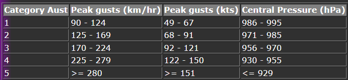
Australian Cyclone Severity Scale (4)
A Severe Tropical Cyclone is a Category 3 or greater cyclone, where the eye is usually showing. The a region of mostly calm weather at the centre, and can be 30 to 65km across in diameter and surrounded by the eye wall. The eye wall is made up of thunderstorms that form a ring around the eye, this is where the most intense winds are present (5).

Eye wall from a plane flown through the eye of Hurricane Epsilon on Wednesday, Oct. 21, 2020. (6)
References
http://www.bom.gov.au/cyclone/tropical-cyclone-knowledge-centre/history/climatology/
http://www.bom.gov.au/cyclone/tropical-cyclone-knowledge-centre/history/tracks/
https://australiasevereweather.com/cyclones/tropical_cyclone_intensity_scale.htm
https://www.britannica.com/science/tropical-cyclone#ref255359
Comments