To get your daily forecast delivered free goto http://wallysweather.com.au/blog
An added thanks to the sponsorship from NQ Licensed Events and the Country Festival on March 30 & 31 at the Dittman Bullpit
Website: https://www.countryfest.com.au/
Facebook: https://www.facebook.com/contryfestqld
Instagram: https://www.instagram.com/countryfestqld/
Monsoon Update
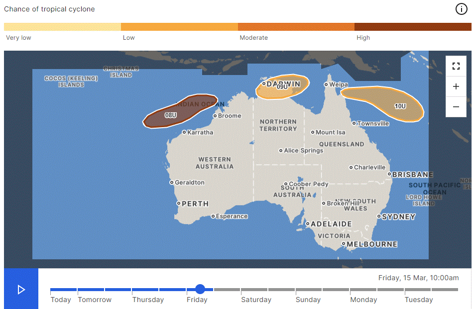
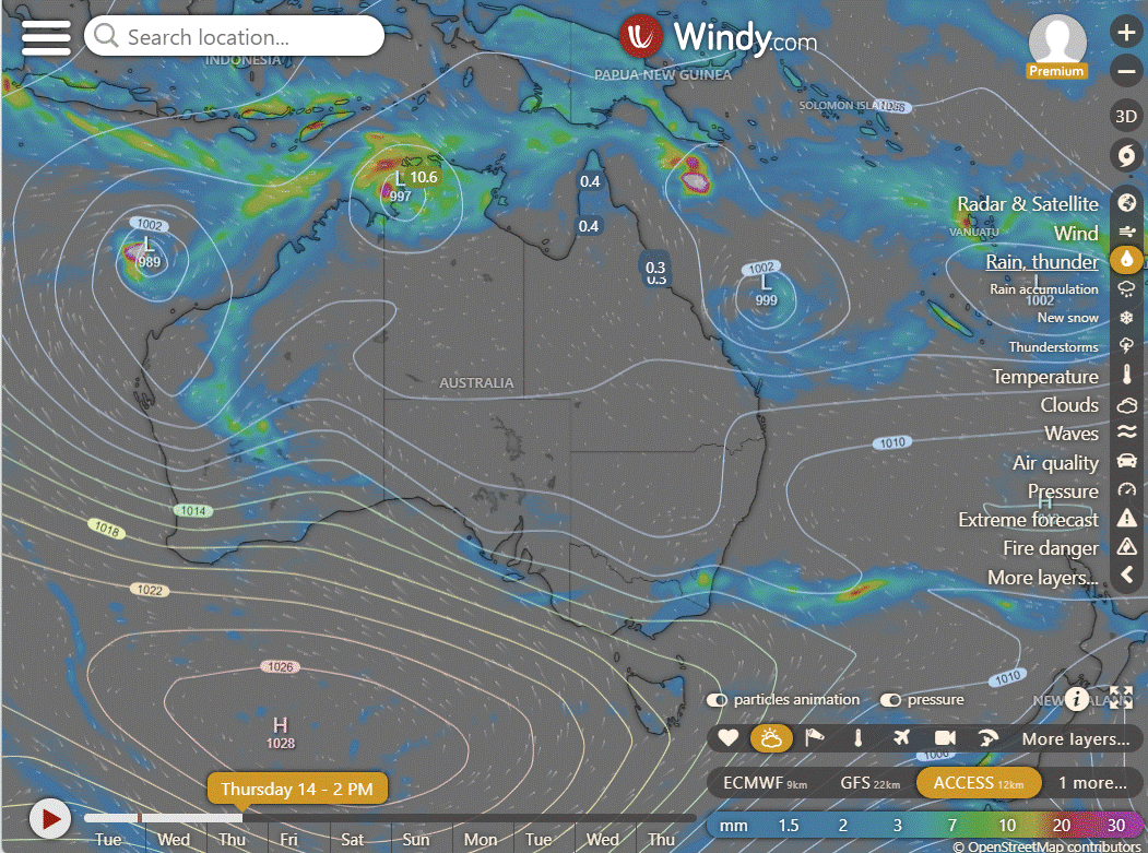
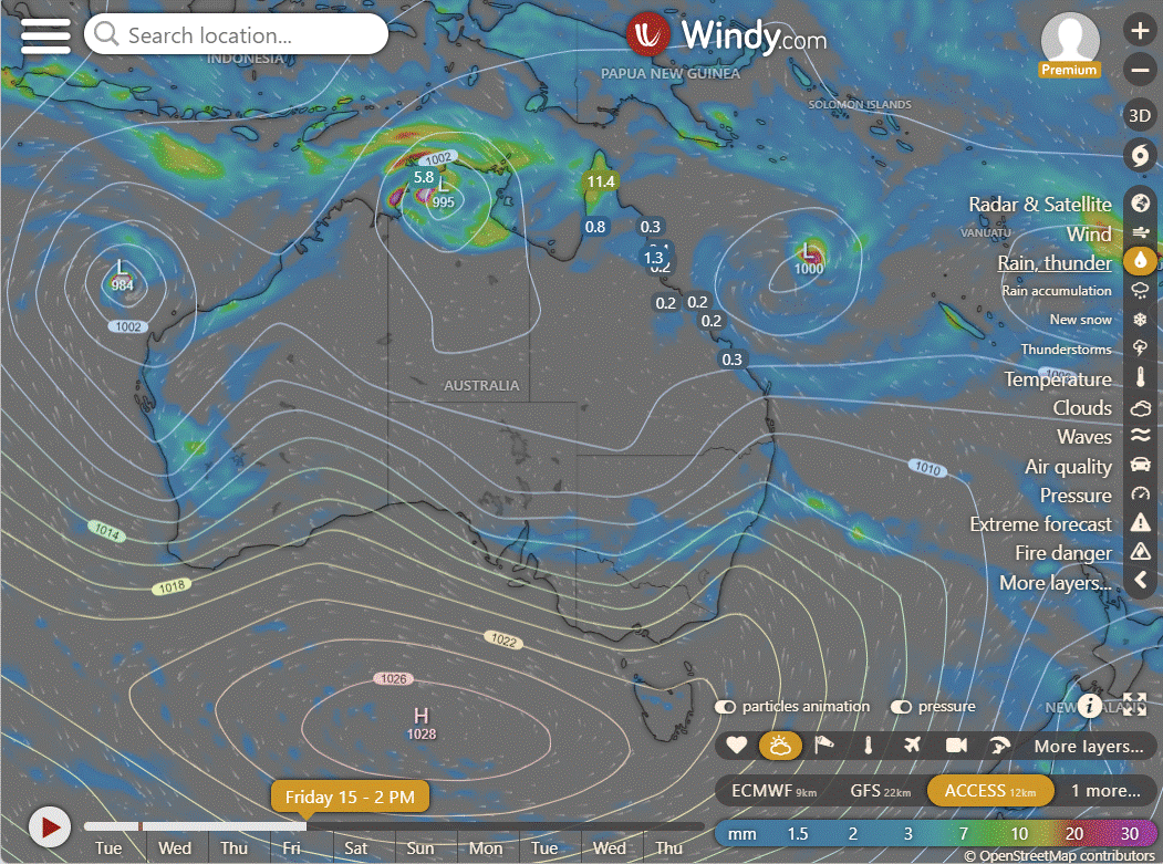
Tropical Low 08U: A high chance of a tropical cyclone forming off the Western Australia coast on Friday with Tropical Low 08U approaching, possibly becoming a category 2 system and posing a small risk of direct impact on the Pilbara coast.
Tropical Low 09U: With a moderate risk of becoming a tropical cyclone in the Gulf of Carpentaria, Tropical Low 09U may form within the monsoon near the north Australian coast, moving east-southeast and potentially crossing the western Top End coast on Wednesday or Thursday, with a reduced risk of cyclone formation over Northern Territory land by Tuesday.
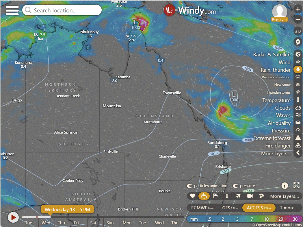
Tropical Low 10U: Presenting a low risk of developing into a tropical cyclone in the Coral Sea, Tropical Low 10U might form off the eastern Top End in the Gulf of Carpentaria, moving east-southeast into the Coral Sea by Thursday and staying well offshore off the east Queensland coast. This is the system that may impact slightly on the Pink concert but only with pushing showers to the coast on Friday. Saturday should be fine. Easter should have early showers then dry, there is a chance a low might be out in the Coral Sea sucking up the rain.
National
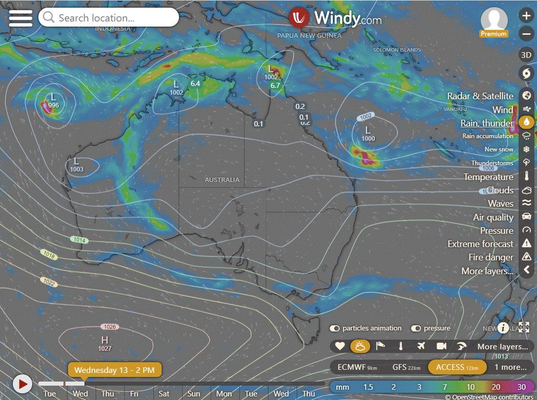
The far north can expect heavy rain and storms due to the monsoon and potential tropical lows, while southeast WA will experience continued rain from lingering tropical moisture. Showers are anticipated in Tas, southern Vic, SA, and eastern Qld amid humid winds, while the interior remains hot and dry.
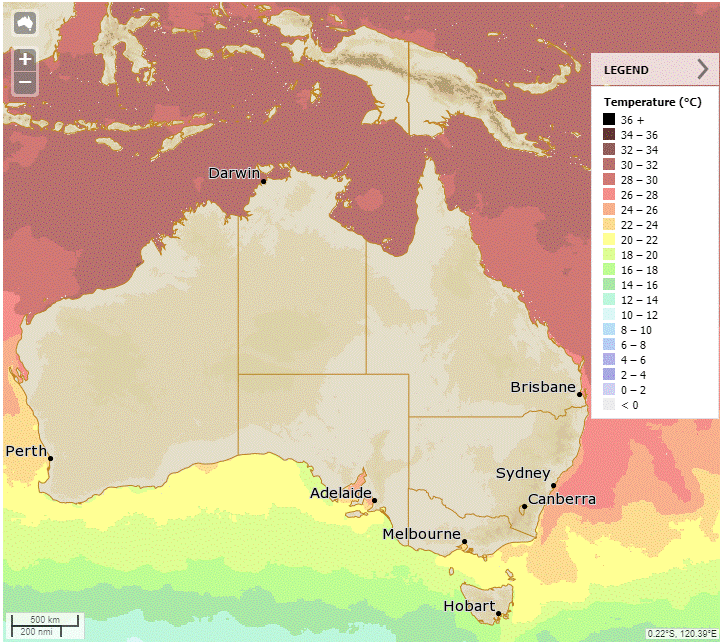
Synoptic | Temp/Rain | Wind | Sea Surface Temp
State
High over Tasman Sea easing, weak trough enhancing rainfall, developing monsoon trough moving southwards, tropical lows may deepen, new high bringing southeasterly winds and showers.
ACCESS (Values are rainfall over 3 hours)
4-day
Wednesday: North of Georgetown: Isolated to scattered showers, chance of isolated thunderstorms north of Kowanyama. Showers increasing over far northern Cape York Peninsula. Eastern districts: Isolated to scattered showers, chance of thunderstorm between Bowen and Bundaberg. Mostly sunny elsewhere. Winds: East to southeasterly, becoming stronger along east coast, moderate to fresh from west to northwesterly in Torres Strait.
Thursday: Spotty showers and possible thunderstorms near Georgetown. Rain at times in far north Cape York, isolated showers in the east, mostly sunny elsewhere. Above average temps, except in far north Peninsula.
Friday: North of Georgetown: Isolated to scattered showers with chance of thunderstorm. Widespread showers at times in northern Cape York Peninsula. Isolated showers in eastern districts. Mostly sunny elsewhere, with possible morning fog in southeast. Maximum temperatures above average across the state, especially in southern interior.
Saturday: Mainly sunny in central west and southwest. Showers scattered elsewhere with possible thunderstorms in north of Georgetown and far southern interior. Showers likely at times in Cape York Peninsula and North Tropical Coast. Above average temperatures in western and southern interior, near average elsewhere.
North Tropical Coast and Tablelands:
Max temperature: 33°C, Min temperature: 19°C, Wind speed: 15-25 km/h easterly to southeasterly, Wind direction: east to southeasterly, Rainfall: Showers near the coast, Partly cloudy.
Herbert and Lower Burdekin:
Partly cloudy with a slight chance of a shower, light winds becoming easterly to southeasterly 15-20 km/h in the afternoon, decreasing in the evening with overnight temperatures between 19-23°C and daytime temperatures in the low to mid 30s, with no mention of specific maximum and minimum temperatures, wind speeds, wind directions, or rainfall measurements.
Central Coast and Whitsundays:
The weather forecast includes maximum temperatures of 28 to 33 degrees, minimum temperatures of 19 to 22 degrees, southeasterly winds at 15 to 25 km/h, a medium chance of showers along the coastal fringe, a slight chance elsewhere, and partly cloudy skies.
Peninsula:
Maximum temperature: 36°C, Minimum temperature: mid 20s, Wind: Light/15-25 km/h, Wind direction: East to southeasterly, Rainfall: Very high chance of rain in north, slight chance elsewhere, other: Partly cloudy, chance of thunderstorm and heavy falls possible in the north, damaging winds possible north of Weipa.
Gulf Country:
Mostly sunny weather with a chance of thunderstorm near the east coast, light winds becoming east to southeasterly 15 to 20 km/h, overnight temperatures in the low to mid 20s and daytime temperatures in the mid to high 30s.
Northern Goldfields and Upper Flinders:
The weather will be mostly sunny with light winds in the morning becoming east to southeasterly 20-30 km/h, then light in the evening, with overnight temperatures between 19-22°C and daytime temperatures in the low to mid 30s, with no rainfall predicted.
Capricornia:
The weather forecast for the day includes a maximum temperature around 30°C, minimum temperature between 18-22°C, southeasterly winds at 20-30 km/h with partly cloudy skies and medium chance of showers near the coast and slight chance elsewhere.
Central Highlands and Coalfields:
The weather will be partly cloudy with light winds in the morning becoming southeasterly at 15-25 km/h, with temperatures ranging from 17-21°C overnight and reaching the low to mid 30s during the day, with no mention of rainfall.
Central West:
Max temperature reaching the mid to high 30s, overnight temperatures falling to 19-23, wind easterly 15-25 km/h becoming light, and sunny conditions with southeasterly winds later in the day.
North West:
The day will start with mostly sunny skies and light winds, with temperatures climbing to the mid to high 30s, before cooling down to the low 20s overnight.
Channel Country:
Max temperature: 40°C, Min temperature: low to mid 20s, Wind speed: light, Wind direction: easterly to southeasterly, Rainfall: none, Other: Sunny.
Maranoa and Warrego:
Maximum temperature: 39°C, Minimum temperature: 17°C, Wind speed: 15-25 km/h, Wind direction: East to southeasterly, Rainfall: Sunny, Other: Light winds becoming light in the evening.
Darling Downs and Granite Belt:
The weather will be mostly sunny with a chance of fog in the morning, light winds becoming easterly 15 to 25 km/h, with temperatures between 15 and 18 overnight and 29 to 35 during the day, with no significant rainfall expected.
Wide Bay and Burnett:
Max temperature: 30°C, Min temperature: 17-21°C, Wind speed: 25-35 km/h southeasterly, Wind direction: Slight chance showers, Rainfall: Partly cloudy
Southeast Coast:
Max temperature around 30 with overnight temperatures falling to between 17 and 22, wind southeasterly 15 to 20 km/h becoming light before dawn, with partly cloudy skies and medium chance of showers in the north and slight chance elsewhere.
WEATHER WARNINGS
NSW/ACT: Hazardous Surf Warning for Byron Coast.
WA: Tropical Cyclone Technical Bulletin; Severe Weather Warning (Heavy, Locally Intense Rainfall) for parts of Goldfields, Eucla, and South Interior districts; Strong Wind Warning for Leeuwin Coast; Ocean Wind Warning For Tropical Cyclone; Moderate Flood Warning For The Fitzroy River.
QLD: Hazardous Surf Warning for Sunshine Coast Waters, Gold Coast Waters & K'gari Coast; Severe Weather Warning (Heavy Rainfall) for parts of Peninsula; Strong Wind Warning for Torres Strait & Townsville, Mackay, Capricornia, and K'gari coasts; Strong Wind Warning Spencer Gulf, Invest St & Lower West, Central, South Central & Lower South East coasts.
NT: Strong Wind Warning for Gove Peninsula Coast; Flood Watch For The North Western NT; Moderate Flood Warning For The Daly River; Minor Flood Warning For The Katherine River; Initial Moderate Flood Warning For The Waterhouse River.
SA: Strong Wind Warning Spencer Gulf, Invest St & Lower West, Central, South Central & Lower South East coasts (Cancelled Upper SE Coast); Heatwave Warning for South Australia; Flood Warning For The Inland Rivers SA.
TAS: Cancelled Wind Warning East of Flinders Is, Derwent, Fred Hen Bay & Norfolks, Storm Bay & Upper East, Lower E, SE & South West coasts; Heatwave Warning for Tasmania.
WA: Flood Watch For The East Kimberly, Salt Lake And Nullarbor District Rivers, Sandy Desert And Parts Of The Pilbara Coast Rivers; Flood Warning For The Ord River; Flood Warning For The Oakover And Nullagine Rivers; Flood Warning For The Eucla District; Flood Warning For The Salt Lakes District Rivers; Flood Warning For The Victoria River.
QLD: Initial Flood Watch For Northern Parts Of The Cape York Peninsula; Minor Flood Warning For The Tully River And Flood Warning For The Murray River.
NT: Minor Flood Warning For The Katherine River; Minor Flood Warning For The Diamantina River; Initial Moderate Flood Warning For The Waterhouse River.
QLD: Minor Flood Warning For The Paroo River (Qld); Flood Warning For The Inland Rivers SA.
NSW/ACT: Minor Flood Warning For The Paroo River (Nsw).
QLD: Moderate Flood Warning For Eyre Creek And Minor Flood Warning For The Georgina River.
QLD: Final Flood Warning For The Flinders River.
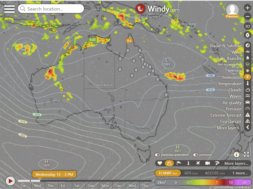
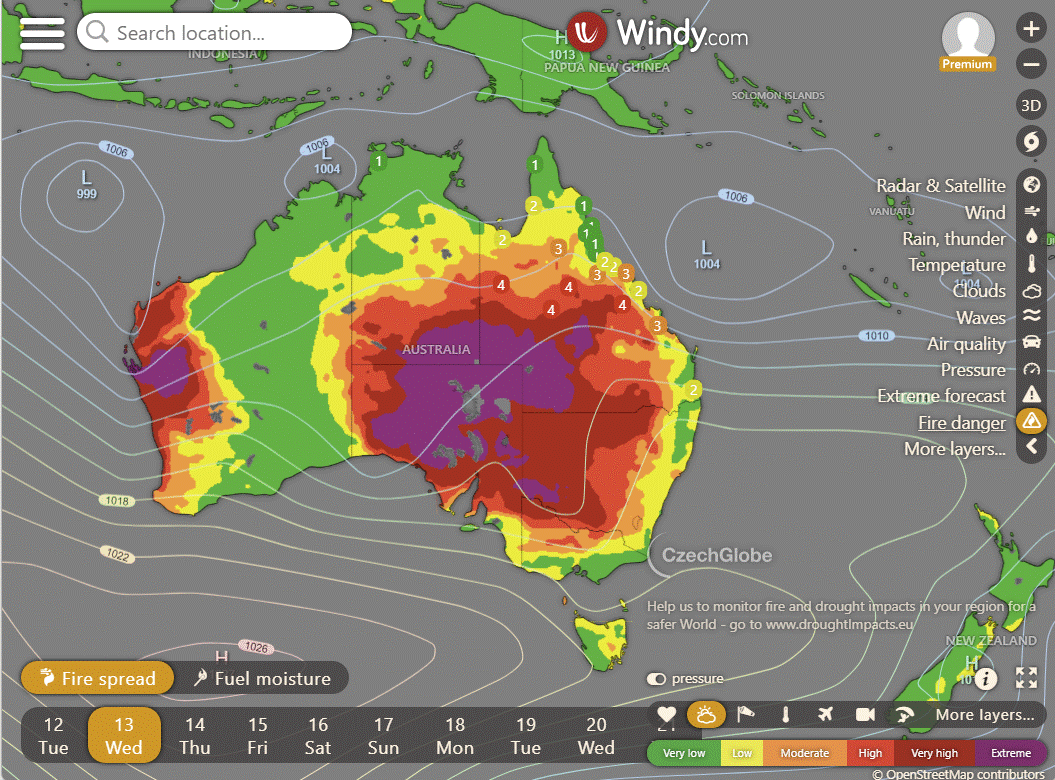
Storms - Heatwave - Fire danger
Click here to support to Wally's Weather
National maps by Weatherzone (weatherzone.com.au)
State maps by Windy (Windy.com)
Weather forecast supplemented by Bureau of Meteorology (bom.gov.au)
Rainfall daily totals (https://meteologix.com/ )
AccuWeather (https://www.accuweather.com/)
Nine Weather (https://www.9news.com.au/weather)
Wally's Weather provides professionally researched data and information. Andrew aka 'Wally' has over 20 years of experience in meteorology research and data analysis. In 2023 finished top 4 for the AMOS national weather forecasting competition. The content here is provided as educational information aimed at providing the community and businesses with the tools required to determine local-based forecasts. IMPORTANT: The forecasts and information posted should never be used on their own to make business decisions as local influences.









Comentarios