This weather update is brought to you by Regional QLD Cat Club
Watch out for some questions to win a family pass to the Regional QLD Cat Club Gone Troppo Show on 1st and 2nd July at the Aitkenvale PCYC.
Competition: To win points you need to attend the Regional QLD Cat Club Gone Troppo Show on 1st and 2nd July at the Aitkenvale PCYC. If you bought a single ticket, you earn 100 points, if you bought a family you get 200 points. But you must send me a photo via your membership email of you and/or your family at the show. Entries close July 10th 2023. Points are awarded at the discretion of Wally's Weather Australia.
Wally's Weather provides professionally researched data and information. Andrew aka 'Wally' has over 20 years of experience in meteorology research and data analysis. The content here is provided as educational information aimed at providing the community and businesses with the tools required to determine local-based forecasts. IMPORTANT: The forecasts and information posted should never be used on their own to make business decisions as local influences.
Click here to support to Wally's Weather
Rain event forecast special
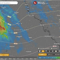
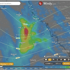
Sunday: Rainfall all along the Western border of QLD, the ACCESS model has it more advanced to the central QLD than this EC forecast. Both are around 30 to 70mm for heavier areas.
Monday: This should still be the heaviest rainfall day, most of the heaviest rain along the coast or off the coast between Bowen and Innisfail according to the EC on this map with up to 125mm over the Burdekin to Ingham and 30 to 70mm over the dividing ranges, ACCESS have lighter rain around 45 to 60mm around the Townsville Burdekin region.
Tuesday: As the trough departs the tail will also produce some heavy falls from Bowen down to Mackay according to the EC.
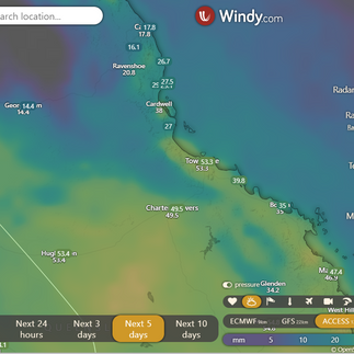
I have added the 5 day accumulation with a closer up view showing more locations and amounts from Windy.com.
National
A high in the Great Australian Bight extends a ridge over Queensland, moving eastward towards the Tasman Sea by Monday. An upper trough brings a cloud band over western Queensland, progressing eastward across the state on Monday and dissipating on Tuesday. A surface trough may develop in the central interior on Monday, weakening into a broad trough over southern and central Queensland on Tuesday. By Friday, the trough moves offshore, allowing a new ridge to extend across the state.
State
Widespread rain in western, central, and northern districts, isolated showers elsewhere, and below-average temperatures in the west and northwest.
4-day
Monday: Cloudy with showers, isolated thunderstorms, and below-average temperatures.
Tuesday: Showers, isolated thunderstorms, and below-average temperatures.
Wednesday: Showers, mostly sunny in the northwest, and temperature variations.
Thursday until Saturday: Showers, mostly sunny, chance of morning frost, and temperature variations.
Townsville
Forecast for the rest of Sunday: Get ready to unleash your inner cat-titude at the Regional QLD Cat Club Gone Troppo Show! Enjoy the sunny morning, but keep an eye out for a sprinkle of rain later tonight, just to keep those cat whiskers fresh and hydrated. The winds will be joining the fun, swaying from east to southeasterly at a gentle pace before calming down in the evening. So grab your cat ears and prepare for a furr-tastic time at the show, where the clawsome vibes and furry friends await!
National maps by Weatherzone (weatherzone.com.au)
State maps by Windy (Windy.com)
Weather forecast supplemented by Bureau of Meteorology (bom.gov.au)
Rainfall daily totals (https://meteologix.com/ )


Opmerkingen