
To get your daily forecast delivered free goto http://wallysweather.com.au/blog
Wally has said, temps are up early ahead of Summer, so....

Welcome Garry Thyer's Betta
Hyde Park Centre
Our prime daily forecast sponsors for through to October inclusive.
Address: Shop 8, Hyde Park Centre, Woolcock St, Hyde Park QLD 4812
Phone: (07) 4721 1211
National - Warnings - 4 Day - State - Min-Max-Rain - Regional Round-Up
National
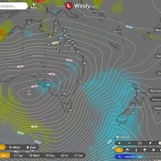
A sturdy high in the Great Australian Bight is throwing some serious shade over the state, while a low in the Tasman Sea is teaming up with the high to send a southeasterly wind surge scampering north along the east coast. On Monday, the low will bid adieu as it heads east, leaving the wind surge to continue its northward journey. By Tuesday, the high will saunter across southeastern Australia before making itself at home in the southern Coral Sea or northern Tasman Sea on Wednesday. It will then casually drift east over the next few days like a leaf on a lazy river. Come Thursday, a trough will waltz into the southwest of the state, sashaying eastward across southern and central Queensland by Friday. This trough may stick around for a day, or it might be followed by a second trough making its grand entrance next weekend or early next week. So, grab your umbrellas and brace yourself for some meteorological drama!


Synoptic | Temp/Rain | Wind | Sea Surface Temp
National Warnings
15/16:05 EST Marine Wind Warning Summary for New South Wales
15/17:00 EST Warning to Sheep Graziers for North East and East Gippsland forecast districts
15/16:00 WST Marine Wind Warning Summary for Western Australia
15/15:27 WST Fire Weather Warning for Central Interior fire weather district
15/15:50 CST Marine Wind Warning Summary for South Australia
15/16:30 CST Warning to Sheep Graziers for Flinders forecast district
15/16:58 EST Warning to Sheep Graziers for South East forecast district
15/10:42 EST Cancellation of Road Weather Alert for Tasmania
15/15:57 CST Fire Weather Warning for Simpson East fire weather district


WINDY.COM Extreme Weather
The 4 day forecast brought to you by our local businesses, you could have this spot with your details, support local, take out a Bold Shout ! $250 for a year, you get this and the website every day!


National 4 Day Forecast


Windy.com NEW ACCESS 4 Day Accumulated Rain and Synoptic
Monday, 16th September
Well, it seems the good ol' west and central districts are facing some rather precarious fire danger ratings. So, you might want to exercise a bit of caution out there.
Tuesday, 17th September
Prepare yourselves for a delightful mix of isolated to scattered showers in eastern districts, the western Gulf Country District, and northern Cape York Peninsula. These showers may even become widespread over the North Tropical Coast, with isolated ones popping up south of Townsville. Don't forget to keep an eye out for morning frost inland in southern and central Queensland, as well as possible morning fog in the southeast. And just to keep things interesting, maximum temperatures will be below average. Enjoy the show!
Wednesday, 18th September
Prepare yourselves for a smattering of showers in the east, western Gulf Country, and northern Cape York Peninsula. Up north, expect a mix of clouds and sunshine. Watch out for frosty mornings inland in the south and central regions, and potential fog in the southeast. Temperatures will be below average up north, but near average elsewhere.
Thursday, 19th September
It seems that some lucky areas will be getting a sprinkle of rain today, specifically in the eastern districts north of Yeppoon, the western Gulf Country District, and over northern Cape York Peninsula. Meanwhile, the rest of us can expect mostly sunny skies. Don't be surprised if you wake up to a bit of frost in the southeast. Temperatures will be near average in the north of Richmond and above average everywhere else. Enjoy the weather, folks!
State

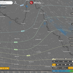


Windy.com ACCESS (Rainfall at 6 hour points over the next 24 hours, 10pm, 4am, 10am, 4pm)
Min - Max - Rain

Regional Round-Up
North Tropical Coast and Tablelands
Well, it appears that we are in for some classic Australian weather - cloudy with a high chance of showers near the coast and a medium chance elsewhere. The winds will be coming from the east to southeasterly direction at speeds of 25 to 35 km/h. As we settle in for the evening, temperatures are expected to drop to between 14 and 20 degrees, so be sure to have your blankets ready. During the day, temperatures will range from 21 to 28 degrees, providing a nice balance for those who enjoy a bit of variety in their weather.
Herbert and Lower Burdekin
Expect some clouds scattered about with a small possibility of a light shower up north, although the chances are slim to none elsewhere. The winds will be coming from the east to southeast at speeds of 20 to 30 km/h. Temperatures will drop overnight to around 14 to 18 degrees, with daytime highs reaching 24 to 29 degrees.
Central Coast and Whitsundays
Expect some clouds floating around today, possibly shedding a tear or two near the coast. Winds will be getting a bit frisky, so hold onto your hats. Temperatures will be playing a little game of hide and seek, dropping down to the teens overnight and then sneaking back up to the mid to high twenties during the day.
Peninsula
Well, it appears we may have some clouds lingering overhead today, with a minuscule possibility of a light drizzle in the eastern regions, but let's not get our hopes up elsewhere. Be prepared for some rather breezy easterly winds blowing at a speed of 25 to 35 km/h. As night falls, temperatures will dip down to a range of 18 to 23 degrees, while daytime temperatures will climb to a toasty 29 to 34 degrees. So, grab your umbrellas and hold onto your hats, it's shaping up to be a thrilling day of weather ahead!
Gulf Country
Expect some clouds hanging around, and there might be a tiny sprinkle near the Northern Territory. But don't worry, chances of rain elsewhere are as slim as your chances of winning the lottery. Winds will be blowing from the east to southeasterly direction, so hold on to your hats. Nighttime temperatures will drop to a pleasant 18 to 22 degrees, while daytime temperatures will reach the low to mid 30s. So, grab your sunscreen and get ready to sweat it out!
Northern Goldfields and Upper Flinders
Expect some scattered clouds today, accompanied by winds blowing from the east at a brisk pace of 25 to 40 kilometers per hour. As night falls, temperatures will drop to a cool 13 to 17 degrees, while during the day, we'll be treated to a range of 27 to 32 degrees. So, grab your windbreaker and prepare for a day of unpredictable weather!
Capricornia
Get ready for a day of sunshine with a slight chance of a shower teasing the coast - though you'd have better luck finding a unicorn elsewhere. The winds will be showing off their flexibility, starting from the south and southeasterly before transitioning to the east and southeasterly, reaching speeds of 15 to 20 km/h in the morning and then kicking it up a notch to 25 to 35 km/h in the afternoon. As night falls, temperatures will be dropping to a cool 9 to 16 degrees, so grab a blanket and cozy up. During the day, you can expect temperatures to rise to the low to high 20s - perfect weather for a picnic or pretending to work from home while lounging in the backyard.
Central Highlands and Coalfields
Expect a generous serving of sunshine today, with a side of breezy conditions. Winds will be indecisive, starting from the east and then switching to the south before finally settling on the east again. Overnight, temperatures will drop to a range that can't make up its mind - somewhere between 5 and 13 degrees. Daytime temperatures will reach the mid to high 20s, giving us a taste of that sweet summer heat. Enjoy the weather rollercoaster ride!
Central West
Well, it seems we're in for another round of the classic "sunny with a chance of wind" scenario. Expect those breezes to be coming from the east to southeasterly direction at a speed of 25 to 40 km/h. As night falls, temperatures will drop to a cool 9 to 15 degrees, but fear not, as the daytime will bring a balmy 30 degrees. So, get ready to embrace the elements and enjoy another day in the never-ending cycle of weather patterns.
North West
Prepare yourself for another scorching day ahead, with the sun making its grand appearance once again. Expect gusty winds from the southeast blowing at speeds of 25 to 40 km/h. As the night creeps in, temperatures will drop to a cool 14 to 19 degrees, giving us a brief respite from the heat. But don't get too comfortable, as daytime temperatures will soar back up to the low to mid 30s. Stay hydrated and find some shade, unless you want to become a crispy critter in this fiery weather.
Channel Country
Expect some good ol' sunshine today, accompanied by southeasterly winds blowing at a brisk 30 to 45 km/h. As the sun sets, temperatures will drop to a cool 8 to 14 degrees, but fear not! Tomorrow's daytime temperatures will rise to a toasty 24 to 30 degrees. So grab your sunscreen and enjoy the weather!
Maranoa and Warrego
Prepare yourselves for another delightful day of sunshine, with winds picking up speed as the morning progresses. Expect overnight temperatures to drop to a crisp 3 to 8 degrees, while daytime temperatures will reach the pleasant low to mid 20s. Enjoy the breeze, but hold on to your hats!
Darling Downs and Granite Belt
Well, it seems like the sun will be making an appearance today, so dig out those sunglasses and slap on some sunscreen. Don't be surprised if you stumble upon some frost near the New South Wales border in the wee hours of the morning - Mother Nature has a quirky sense of humor. The winds will be having a bit of an identity crisis, starting off southeasterly at 15 to 20 km/h, then switching to south to southwesterly at 15 to 25 km/h in the late morning, only to become southerly and light by the late evening. Overnight temperatures will be dropping down to a chilly 2 to 7 degrees, so be sure to snuggle up tight. Daytime temperatures will be reaching the low to mid 20s, so enjoy the warmth while it lasts. Just another day in the life of weather unpredictability!
Wide Bay and Burnett
Well, it seems like Mother Nature decided to give us a break from her usual dramatic weather antics today. You might want to grab your sunglasses because it's looking mostly sunny out there. There's a slight chance of a shower along the coastal fringe in the early morning, but let's be real, that's not going to ruin anyone's day. The winds will be southeasterly at 15 to 25 km/h, but don't worry, they'll calm down by the evening. As for temperatures, we're looking at overnight lows between 7 and 14 degrees, so maybe grab an extra blanket. Daytime temperatures will be in the low to mid 20s, so it's not exactly beach weather, but it's not too shabby either. Just another day in the exciting world of weather forecasting!
Southeast Coast
Wear your shades and hold onto your hats, because we've got some southeasterly winds at 15 to 20 km/h, shifting to the east in the late afternoon before calming down in the evening. Temperatures will drop overnight to a crisp 6 to 11 degrees, but fear not - we'll be back in the low to mid 20s during the day. So, get ready to bask in the sunshine and enjoy the gentle breeze.
Click here to support to Wally's Weather
National maps by Weatherzone (weatherzone.com.au)
State maps by Windy (Windy.com)
Weather forecast supplemented by Bureau of Meteorology (bom.gov.au)
Rainfall daily totals (https://meteologix.com/ )
AccuWeather (https://www.accuweather.com/)
Nine Weather (https://www.9news.com.au/weather)
Wally's Weather provides professionally researched data and information. Andrew aka 'Wally' has over 20 years of experience in meteorology research and data analysis. In 2023 finished top 4 for the AMOS national weather forecasting competition. The content here is provided as educational information aimed at providing the community and businesses with the tools required to determine local-based forecasts. IMPORTANT: The forecasts and information posted should never be used on their own to make business decisions as local influences.
Comments