To get your daily forecast delivered free goto http://wallysweather.com.au/blog
Main Sponsorship to go here for Daily Available, email wallysweatheraustralia@gmail.com for details.
National - Warnings - 4 Day - State - Min-Max-Rain - Regional Round-Up
National
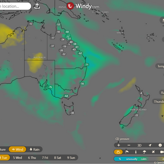
Showers over South Australia and the interior due to humid winds. A low near Tasmania weakens and moves further away, causing showers and winds to gradually ease along the southeast coast. High pressure sends showers in moist winds to far north and southwest Western Australia, while keeping other regions dry.


Synoptic | Temp/Rain | Wind | Sea Surface Temp
National Warnings
WA: Strong Wind Warning for Eucla Coast, Cancellation for Esperance Coast
NSW/ACT: Cancellation of Surf Warning for Hunter, Sydney, Illawarra, Batemans, and Eden coasts
VIC: Frost Warning for Wimmera
SA: Frost Warning for Lower South East
VIC: Cancellation of Sheep Graziers Warning for East Gippsland
SA: Cancellation of Wind Warning for Far West, Upper West, Lower West, and Central coasts
NSW/ACT: Sheep Graziers Warning for Northern Tablelands and Southern Tablelands
TAS: Strong Wind Warning for Banks St & Franklin Sound, East of Flinders Is, Far NW & CN coasts, Cancellation for Upper East, Lower East, and South East coasts
VIC: Gale Warning for Central Gippsland and East Gippsland coasts, Strong Wind Warning for Central Coast
NSW/ACT: Strong Wind Warning for Macquarie, Hunter, and Illawarra coasts, Cancellation for Batemans and Eden coasts
NSW/ACT: Gale Warning for Southern Area
NSW/ACT: Gale Warning for Western, Southeastern, and Southern Areas
NSW/ACT: Gale Warning for Western and Southern Areas
TAS: Initial Minor Flood Warning for The St Pauls River
NSW/ACT: Final Flood Warning for The Wollombi Brook
NSW/ACT: Final Flood Warning for The Williams River
WA: Cancellation of Sheep Graziers Warning for Lower West and South West


WINDY.COM Extreme Weather
The 4 day forecast brought to you by our local businesses, you could have this spot with your details, support local, take out a Bold Shout ! $250 for a year, you get this and the website every day!


National 4 Day Forecast


Windy.com ACCESS 4 Day 2PM Rain and Synoptic
Tuesday: Mainly clear and cool statewide with high cloud in the southwest. Partly cloudy with few showers in the east. Light winds becoming moderate southwest in the southeast and moderate southeast in the tropics.
Wednesday: East QLD: Cloud increasing. Isolated showers south/east. Scattered showers in parts. NW mostly sunny. Below average temps in NW and SE. Max temps below average in south/west.
Thursday: Partly cloudy with isolated showers in east and south Queensland, becoming scattered in the southeast. Mostly sunny elsewhere. Fresh south to southeast winds on tropical coasts. Below average temperatures in northern and western areas, near average on east coast and Peninsula. Lower temperatures in interior and northwest.
Friday: Partly cloudy with isolated showers in some areas. Frost possible in the southeast to central interior. Below average temperatures expected.
State


Windy.com ACCESS (Values are rainfall over 3 hours)
High pressure from near Victoria brings cool dry conditions to most of Queensland. Showers expected in central and southern Queensland mid-week.
Min - Max - Rain
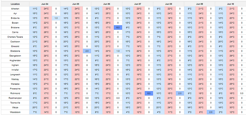
Regional Round-Up
North Tropical Coast and Tablelands:
The weather will be mostly sunny with temperatures ranging from 12 to 29 degrees Celsius, light winds becoming northeast to southeasterly at 15 to 20 km/h in the morning, then becoming light in the late afternoon with overnight temperatures between 12 and 18.
Herbert and Lower Burdekin:
Mostly sunny with light winds, overnight temperatures between 9 and 15, daytime temperatures in the mid to high 20s, with no mention of wind speed, wind direction, rainfall or extreme temperatures.
Central Coast and Whitsundays:
Maximum temperature in the low to high 20s, minimum temperature between 6 and 11, light winds from the Sunny direction, with no rainfall.
Peninsula:
Expect a warm day with maximum temperature reaching the low 30s, minimum temperature between 15 and 21, light winds becoming east to southeasterly at 15 to 20 km/h in the morning, slight chance of a shower near the east coast, near zero chance elsewhere, and mostly sunny conditions.
Gulf Country:
The weather will be sunny with light winds transitioning to northwest to southwesterly at 15 to 20 km/h before becoming light again at nighttime, with temperatures ranging from 9 to 17 overnight and reaching 26 to 31 during the day, and no rainfall is expected.
Northern Goldfields and Upper Flinders:
The weather will be mostly sunny with temperatures ranging from 30 to 7-14, light winds becoming northwest to northeasterly 15-25 km/h in the morning, then shifting to northwest to southwesterly in the early afternoon and overnight.
Capricornia:
Max temperature in the low to mid 20s, minimum temperature between 4 and 9, light winds with sunshine and chance of fog in southwest early morning, no rainfall.
Central Highlands and Coalfields:
Max temperature: 27°C, Min temperature: 2°C, Wind: light, Rainfall: none, Other: Sunny with patches of frost and chance of fog in the south in the morning.
Central West:
Max temperature: 28°C, Min temperature: 4°C, Wind speed: 15-25 km/h, Wind direction: NE to SE, Rainfall: 0mm, Mostly sunny with morning frost and transitioning winds.
North West:
Temperatures will range from 5-9°C overnight to low-mid 20s during the day, with light winds and partly cloudy skies. Slight chance of shower in the southwest, near zero chance elsewhere.
Channel Country:
Maximum temperature between 16 and 21, minimum temperature around 9, light winds becoming northwest to southwesterly 15 to 20 km/h, Partly cloudy with medium chance of showers near the South Australian border and slight chance elsewhere.
Maranoa and Warrego:
Partly cloudy with patches of frost and fog in the morning, light winds, max temp 20, min temp 2, wind speed light, wind direction variable, rainfall none.
Darling Downs and Granite Belt:
The day will start with fog and frost, then a mostly sunny day with light winds, temperatures ranging from 16 to 19, wind speeds generally low, and successful overnight temperatures dropping to around 4.
Wide Bay and Burnett:
Max temperature: 22°C, Min temperature: 3°C, Wind speed: Light, Wind direction: East, Rainfall: None, Other: Sunny with chance of fog and frost inland in the morning.
Southeast Coast:
Max temperature: 21°C, Min temperature: 4°C, Wind speed: 15 to 25 km/h becoming light, Wind direction: Westerly, Rainfall: None, Mostly sunny.
Click here to support to Wally's Weather
National maps by Weatherzone (weatherzone.com.au)
State maps by Windy (Windy.com)
Weather forecast supplemented by Bureau of Meteorology (bom.gov.au)
Rainfall daily totals (https://meteologix.com/ )
AccuWeather (https://www.accuweather.com/)
Nine Weather (https://www.9news.com.au/weather)
Wally's Weather provides professionally researched data and information. Andrew aka 'Wally' has over 20 years of experience in meteorology research and data analysis. In 2023 finished top 4 for the AMOS national weather forecasting competition. The content here is provided as educational information aimed at providing the community and businesses with the tools required to determine local-based forecasts. IMPORTANT: The forecasts and information posted should never be used on their own to make business decisions as local influences.
Comments