To get your daily forecast delivered free goto http://wallysweather.com.au/blog
Main Sponsorship to go here for Daily Available, email wallysweatheraustralia@gmail.com for details.
National - Warnings - 4 Day - State - Min-Max-Rain - Regional Round-Up
National
A crossing front will bring showers, storms, gusty winds, and some alpine snow to southeast South Australia, Victoria, and Tasmania. In Western Australia, a weak front will cause showers, gusty winds, and occasional storms in the west and south. High pressure will maintain dry and mostly clear conditions elsewhere, with a chilly morning expected in the east.

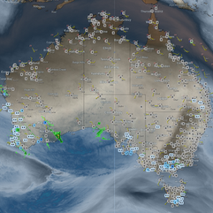


Synoptic | Temp/Rain | Wind | Sea Surface Temp
National Warnings
QLD
Strong Wind Warning for Peninsula Coast
NSW/ACT
Gale Warnings for Western, Southern, Southeastern, and Southern areas
Final Gale Warnings for Western and Southern areas
Strong Wind Warning for Eden Coast
Minor Flood Warning for St Georges Basin
Minor to Moderate Flood Warning for the Hawkesbury and Lower Nepean Rivers
Final Flood Warnings for Hastings River and Cooks River
Cancellation of Sheep Graziers Warning for Snowy Mountains
WA
Gale Warnings for Lancelin, Perth, Bunbury Geographe, and Leeuwin Coasts
Strong Wind Warnings for Perth Local Waters, Geraldton, Albany, Esperance, and Eucla coasts
VIC
Frost Warning for North Central and Central regions
Strong Wind Warning for East Gippsland Coast
SA
Strong Wind Warning for Monday for Central, South Central, Upper South East, and Lower South East coasts
TAS
Gale Warnings for Monday for South West and Central West coasts
Strong Wind Warnings for Monday for Far North West and South East coasts


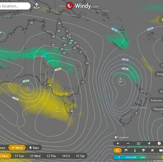


WINDY.COM Extreme Weather
The 4 day forecast brought to you by our local businesses, you could have this spot with your details, support local, take out a Bold Shout ! $250 for a year, you get this and the website every day!


National 4 Day Forecast


Windy.com ACCESS 4 Day 2PM Rain and Synoptic
Monday: Mainly sunny with some clouds in the south and southeast, morning fog possible, patchy morning frosts, cooler in most areas, east-southeast winds in the north, temperatures near average.
Tuesday: Sunny with fog and frost. Chilly morning. Winds in north. Cold south except north. Warmer highs.
Wednesday: Mainly sunny statewide with fog possible in the southeast, frost possible in the south to central interior. Min temperatures near average in the south, below average in central and north QLD south of Coen. Max temperatures above average in most areas.
Thursday: Mainly sunny with a slight chance of showers in the North Tropical Coast. Morning frost possible in the southern to central interior. Temperatures mostly around average, cooler in the south and warmer elsewhere.
State


Windy.com ACCESS (Values are rainfall over 3 hours)
High pressure over central Australia brings cool, dry winds across the state, moving east next week for dry, settled weather. New high in Great Australian Bight will keep conditions stable.
Min - Max - Rain

Regional Round-Up
North Tropical Coast and Tablelands:
Maximum temperature: 27°C, Minimum temperature: 6°C, Wind speed: 15 to 25 km/h, Wind direction: East to southeasterly, Rainfall: None, Weather: Mostly sunny
Herbert and Lower Burdekin:
Max temperature in the mid to high 20s, min temperature between 5 and 11, light winds, sunny with rainfall, overnight temperatures falling.
Central Coast and Whitsundays:
The weather will be sunny with light winds, and temperatures will range from 5 to 10 overnight, reaching the low to high 20s during the day, with no rainfall expected.
Peninsula:
The weather will be sunny with light winds becoming east to southeasterly 15 to 25 km/h in the morning then becoming light in the evening, with overnight temperatures between 11 and 21 degrees and daytime temperatures reaching around 30 degrees.
Gulf Country:
The max temperature is around 30, with min temperatures between 9 and 13, southeasterly winds of 15 to 25 km/h becoming light in the evening, and a sunny day with no rainfall expected.
Northern Goldfields and Upper Flinders:
Max temperature: 30°C, Min temperature: 5-9°C, Wind speed: 15-25 km/h, Wind direction: East to southeasterly, Rainfall: None, Other: Sunny
Capricornia:
Max temperature: low to mid 20s; Min temperature: 4-9; Wind speed: Light winds becoming southerly 15 to 20 km/h, then light; Wind direction: Southerly to light; Rainfall: Not specified; Other: Sunny.
Central Highlands and Coalfields:
Max temperature: 21 to 27, Min temperature: 2 to 5, Wind: Light, Wind direction: Variable, Rainfall: None, Other: Sunny with patches of frost and chance of fog in the south in the morning.
Central West:
The weather will be mostly sunny with morning frost in the southeast, light winds becoming southeasterly 15 to 20 km/h, overnight temperatures between 4 and 7, and daytime temperatures ranging from low to high 20s.
North West:
Maximum temperature: mid to high 20s, Minimum temperature: between 6 and 11, Wind speed: southeasterly 15 to 25 km/h, Wind direction: becoming light, Rainfall: Sunny, Other: Light winds becoming southeasterly 15 to 25 km/h in the morning then becoming light in the evening.
Channel Country:
Max temperature: 25°C, Min temperature: 7°C, Wind speed: Light, Wind direction: Sunny, Rainfall: None, Other: Fog near New South Wales border in early morning.
Maranoa and Warrego:
The weather will be mostly sunny with morning frost in the northeast, a chance of morning fog, light winds becoming south to southeasterly 15 to 20 km/h in the late afternoon then light in the evening, with overnight temperatures dropping to 1-5°C and daytime temperatures reaching around 20°C.
Darling Downs and Granite Belt:
The weather will be mostly sunny with patches of morning frost in the east, a chance of morning fog, light winds becoming southwesterly 15 to 20 km/h by midday and light in the late afternoon, with overnight temperatures falling to around 3°C and daytime temperatures reaching around 18°C.
Wide Bay and Burnett:
The maximum temperature will be around 24 degrees Celsius with minimum temperature dropping to around 3 degrees Celsius, light winds will start from the southwest at 15 to 20 km/h in the morning and then become light in late afternoon, there will be a chance of morning frost inland and it will be sunny with no rainfall expected.
Southeast Coast:
The weather will be cool with a range of 5-10°C overnight, reaching low 20s during the day with sunny skies, light winds turning southwesterly at 15-20 km/h and decreasing in the late afternoon while being dry.
Click here to support to Wally's Weather
National maps by Weatherzone (weatherzone.com.au)
State maps by Windy (Windy.com)
Weather forecast supplemented by Bureau of Meteorology (bom.gov.au)
Rainfall daily totals (https://meteologix.com/ )
AccuWeather (https://www.accuweather.com/)
Nine Weather (https://www.9news.com.au/weather)
Wally's Weather provides professionally researched data and information. Andrew aka 'Wally' has over 20 years of experience in meteorology research and data analysis. In 2023 finished top 4 for the AMOS national weather forecasting competition. The content here is provided as educational information aimed at providing the community and businesses with the tools required to determine local-based forecasts. IMPORTANT: The forecasts and information posted should never be used on their own to make business decisions as local influences.
Comments