To get your daily forecast delivered free goto http://wallysweather.com.au/blog

Welcome Garry Thyer's Betta
Hyde Park Centre
Our prime daily forecast sponsors for August to October inclusive.
Address: Shop 8, Hyde Park Centre, Woolcock St, Hyde Park QLD 4812
Phone: (07) 4721 1211
National - Warnings - 4 Day - State - Min-Max-Rain - Regional Round-Up
National
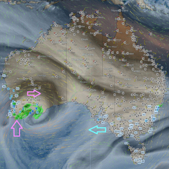
A low in the Bight is taking its sweet time, so expect strong winds and showers in WA's south to slowly wind down. Meanwhile, that same low will crank up the gusty winds and showers over SA. Moist winds will keep coastal NSW a bit soggy, while high pressure ensures the rest of the country stays comfortably dry.
Synoptic | Temp/Rain | Wind | Sea Surface Temp
National Warnings
Sheep Graziers Warning for South Coastal, South East Coastal, and Great Southern districts in WA
Strong Wind Warning for Far West and Upper West coasts in SA
Frost Warning for West and South Gippsland and East Gippsland in VIC
Frost Warning for Midlands and Upper Derwent Valley in TAS
Strong Wind Warning for Coffs, Macquarie, Hunter, Sydney, and Illawarra coasts in NSW; cancellation for Batemans Coast
Severe Weather Warning (Damaging Winds and Heavy Rainfall) for parts of South West, South Coastal, and Great Southern districts in WA
Gale Warnings for Southern, Western, and Southeastern areas in NSW
Gale Warning for Leeuwin and Albany coasts; Strong Wind Warning for various coasts in WA
Cancellation of Sheep Graziers Warning for Northern Tablelands in NSW
Flood Warning for South West District in WA
Cancellation of Wind Warnings for Central Gippsland and East Gippsland coasts in VIC
Cancellation of Wind Warnings for multiple coasts in TAS
Minor Flood Warning for the Lachlan River in NSW
WINDY.COM Extreme Weather
The 4 day forecast brought to you by our local businesses, you could have this spot with your details, support local, take out a Bold Shout ! $250 for a year, you get this and the website every day!
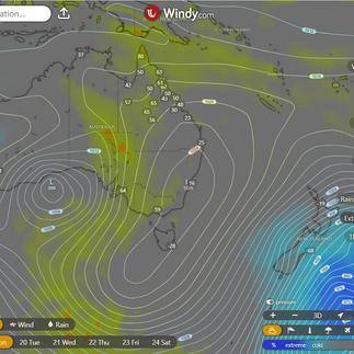
National 4 Day Forecast
Windy.com ACCESS 4 Day 2PM Rain and Synoptic
Monday: Expect some breezy charm with moderate west to southwesterly winds in southeastern Queensland. Winds elsewhere will be as indecisive as your friend trying to choose a movie to watch.
Tuesday: the weather forecast for Queensland is a mixed bag: some clouds with a chance of rain up north and in the southeast, sprinkled showers in the Wide Bay and eastern Peninsula areas, while the rest can enjoy mostly sunny skies. Hold onto your hats for those fresh and gusty winds in the southwest! Temperatures will be playing games - near average in the east, above average elsewhere, and skyrocketing in the far west. And yes, the western districts might want to be extra cautious with that high fire danger lurking about.
Wednesday: Unleashing a dazzling show of partly cloudy skies with spontaneous showers along the shy east coast and Torres Strait. Elsewhere, basking in the radiant glow of mostly sunny conditions. Keep an eye out for elusive morning fog lingering south of St. Lawrence. Temperatures playing it cool near the east coast, flaunting their above-average status elsewhere, and showing off their sizzling style in the far west. Just your typical day in the whimsical world of weather!
Thursday: Sprinkling a bit of rain on the east coast north of Yeppoon, Torres Strait, and in the southern Downs - you might need an umbrella if you're in those areas! Meanwhile, the rest of the region is basking in glorious sunshine. Temperatures are playing it cool above average, with some parts really turning up the heat in the interior.
State
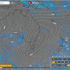
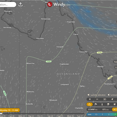
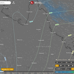
Windy.com ACCESS (Values are rainfall over 3 hours)
Behold, a high sauntering over the Southern Ocean graciously bestows a feeble ridge upon Queensland. This high, feeling a tad adventurous, shall embark northeast into the Tasman Sea come Monday, stirring up onshore winds and reigniting showers along the east coast. But fear not, for it shall bid farewell to the east by week's end! Meanwhile, a rather slothful trough plans to meander into southwestern Queensland on Tuesday, serenading the region with warm, boisterous northerly winds. Oh, the whimsical dance of the weather!
Min - Max - Rain
Regional Round-Up
North Tropical Coast and Tablelands:
Temperatures will range from 13-18°C at night and 25-32°C during the day, with light winds turning easterly to southeasterly at 15-25 km/h in the morning. Expect mostly sunny skies with a slight chance of a coastal shower at night, while elsewhere rain is nearly non-existent for the day.
Herbert and Lower Burdekin:
Tomorrow's forecast includes a pleasant mix of sunshine and mild temperatures, with light winds initially before transitioning to a gentle breeze blowing from the east to northeast, making for a charming day where temperatures hover between 13 to 17 degrees overnight and reach a high of around 30 degrees during the day.
Central Coast and Whitsundays:
Expect warm and pleasant temperatures reaching 25 to 30 degrees, with a slight chance of morning fog in the south, transitioning to light and breezy east to northeasterly winds at 15 to 25 km/h, and overnight lows between 11 and 15 degrees.
Peninsula:
Daytime temperatures in the high 30s with light winds becoming easterly, keeping showers to the east and rare elsewhere, the ideal mix for a sunny day on the horizon.
Gulf Country:
Expect a balmy day starting off brightly with sunny skies, light breezes transitioning to southeasterly winds in the wee hours, followed by a midday lull, as temperatures drop overnight to a cozy range between 12 and 17, while daytime heats up to the low to mid 30s.
Northern Goldfields and Upper Flinders:
Temperatures will drop at night (11-16°C) but rise during the day (30-35°C), with a shift from gentle to moderate breeze coming from the east to northeast in the morning under clear skies.
Capricornia:
Partly cloudy with fog possible in the north early, light winds becoming easterly to northeasterly in the afternoon, overnight temperatures dropping to 7-12°C, highs in the 20s, chance of rain minimal, other conditions are uneventful but pleasant.
Central Highlands and Coalfields:
Expect a pleasant day ahead with temperatures rising up to 25-30 degrees with morning winds calm, turning slightly cool at night with a chance of rain and a few surprises.
Central West:
Expect a delightful day with temperatures reaching a toasty 29-34°C, light breezes swirling in all directions at 15-25 km/h, and a chance for overnight snuggling as temperatures drop to a cozy 7-11°C.
North West:
Expect bright skies, gentle breezes, nighttime temps dropping to 7-12°C and daytime highs hitting the balmy low to mid 30s, so grab your sunscreen and a fan!
Channel Country:
Daytime temperatures will sizzle between 27 to 32 degrees, with overnight lows of around 9, as winds gracefully shift from easterly to northeasterly at 15 to 30 km/h while chasing every leaf in a swirl dance, and a touch of rainfall in slumber followed by a dash of other.
Maranoa and Warrego:
Expect pleasantly warm sunny weather with a touch of a gentle breeze shifting to the east-northeast, creating a perfect day to soak up some vitamin D while keeping an eye out for your hat in the light winds, preparing for temperatures ranging from cozy overnight lows to comfortably warm daytime highs.
Darling Downs and Granite Belt:
Partly sunny, tiny possibility of a sprinkle near Granite Belt, hardly any elsewhere; gentle breezes switching to east-northeasterly 15-20 km/h in the a.m.; lows around 5°C, highs in the low to mid 20s, keeping it cool and comfortable throughout the day.
Wide Bay and Burnett:
Expect mild nights with temperatures dropping to between 5 and 9 degrees, alongside pleasant daytime temperatures ranging from the low to mid 20s, featuring a delightful combination of sunshine and gentle winds.
Southeast Coast:
Expect a peep of clouds, potential showers by the coast, whimsical breezes shifting east to southeasterly, nighttime dipping to 7-12°C, while daytime warms to low to mid 20s.
Click here to support to Wally's Weather
National maps by Weatherzone (weatherzone.com.au)
State maps by Windy (Windy.com)
Weather forecast supplemented by Bureau of Meteorology (bom.gov.au)
Rainfall daily totals (https://meteologix.com/ )
AccuWeather (https://www.accuweather.com/)
Nine Weather (https://www.9news.com.au/weather)
Wally's Weather provides professionally researched data and information. Andrew aka 'Wally' has over 20 years of experience in meteorology research and data analysis. In 2023 finished top 4 for the AMOS national weather forecasting competition. The content here is provided as educational information aimed at providing the community and businesses with the tools required to determine local-based forecasts. IMPORTANT: The forecasts and information posted should never be used on their own to make business decisions as local influences.












Comments