We're thrilled to welcome Painting Professionals as our Leading Sponsor for the next 8 months, Daily, Monthly and Long Range Forecast!

We specialise in being the best of the best period.
The old saying "you get what you pay for".
We definitely aren't the cheapest and don't claim to be.
But if you want the best quality, with the best quality paints, backed with a 12 year year warranty!
Then get in contact with the team and see what we can do for you.
SPECIAL OFFER
15% discount for all wally members. And 15% discount for all ADF and emergency service personnel.
Ph +61 417 065 781
National Synoptic Situation
National Temperature and Rainfall

Rain typically refers to steady, continuous precipitation that lasts for a longer period, sometimes hours or even days. It can vary in intensity, but it's usually more consistent and widespread.
Showers, on the other hand, are shorter bursts of rain, often intermittent. They can be heavy but usually don't last long. Showers are more sporadic and may be followed by dry periods or other types of weather, like sun or clouds.
National Synoptic Situation
QLD:
Well folks, it looks like Tropical Cyclone Alfred is making its grand entrance, bringing with it some strong winds and big waves for the southeast coast. Don't worry, it's just passing through for a quick visit before heading further inland to take a nap and eventually disappearing next week. In the meantime, there's a weak trough hanging around the western and central interior, just chilling out for a few days. And if you thought that was exciting, a ridge will be making its way up the east coast on Sunday, spreading moisture all over eastern and northern Queensland. So get ready for some wet and wild times ahead!
NSW and ACT:
Well, looks like Tropical Cyclone Alfred is making its grand entrance to southeast Queensland, ready to cause some chaos before disappearing like a bad date on Sunday. Get your raincoats and umbrellas ready, because this system is bringing heavy rainfall, flooding, and winds that could rival Aunt Mildred's infamous wind gusts. And don't forget about the damaging surf and high tides along the coast - it's like a free roller coaster ride, minus the fun. Meanwhile, in other parts of New South Wales, a high pressure ridge is taking over like a strict parent, bringing some stability to the state. But don't get too comfortable, because the remnants of Cyclone Alfred are planning a road trip inland, spreading wet conditions like a leaky faucet to central, eastern, and southern areas. So, grab your galoshes and prepare for a wet and wild ride through the week. Stay safe out there, folks!
VIC:
Well folks, it looks like we've got a high pressure system hanging out in the southwest, making sure we get a nice southeasterly airstream in Victoria. As we head into Friday and Saturday, those winds are going to shift to the warmer side coming from the east to northeast. But hold onto your hats, because on Sunday we've got a low pressure trough creeping in from the west, bringing along the remnants of Tropical Cyclone Alfred from eastern NSW. And just when you thought it couldn't get any more exciting, a big high pressure system is set to make its grand entrance from the waters southwest of Tasmania. This means we can expect an east to southeasterly airstream over Victoria as Tropical Cyclone Alfred continues its journey over the Tasman Sea. So grab your umbrella and sunscreen, folks, it's going to be a wild ride!
SA:
So, here's the deal - there's a high pressure system hanging out down south near the Bight, but it's not sticking around for long. It's going to mosey on eastwards and set up camp east of Tasmania by Friday. This high is going to throw a ridge over the waters south of SA on Saturday, before another high crashes the party from the west on Sunday and early next week. Meanwhile, up north in SA, there's a low pressure system throwing a tantrum over the weekend and into early next week. A trough might even make an appearance over the western districts on Monday, before slowly creeping eastwards during the middle of the week. So, basically, we've got a high pressure system playing musical chairs with lows and troughs. Just your typical weather drama unfolding before our very eyes. Just remember your umbrella and sunscreen, folks - you never know what these weather systems have up their sleeves.
WA:
So, there's this trough hanging out near the Pilbara coast and creeping into the far southern Kimberley. It's like that one friend who never knows when to leave a party. But fear not, this trough is expected to finally move offshore from the Pilbara coast in the morning. Why? Because a high pressure ridge to the south is flexing its muscles and sending fresh southeasterly winds our way. So, get ready for some breezy conditions, folks. Time to break out the windbreakers and hold onto your hats!
TAS:
Well, it looks like we've got a high center making its way over to Tasmania, bringing some warm northerly winds with it. This high will stick around for the weekend, giving us some nice weather to enjoy. But don't get too comfortable, because a trough is expected to swing by on Monday, followed by another high moving in from the west. So get ready for some changes in the weather ahead!
NT:
Well folks, it seems like a wimpy ridge up north is causing some scattered showers and thunderstorms to pop up here and there. But fear not, this ridge is set to throw in the towel by the end of the week, giving us a chance to experience more of that sweet, sweet rain action. Meanwhile, we've got a trough chilling out across the Gregory and northern Barkly Districts. The ridge hanging out to the south of this trough is also planning its exit strategy for the weekend, as a high decides to take a leisurely stroll to the east and another trough decides to crash the party over in WA. So, to sum it up in a nutshell: expect some scattered showers and thunderstorms up north, with a side of increasing action towards the end of the week. And don't forget about that trough and those shifting ridges – they're like the drama queens of the weather world, always making a scene. Stay tuned for more updates, because you never know what Mother Nature has up her sleeve next.
National Weather Warnings
New South Wales
Victoria
Queensland
Western Australia
South Australia
Tasmania
Northern Territory
National Storms and Rain Accumulation outlook


Four Day Forecasts
If you run a business and would like the benefits of a Big Shout plus your business promoted for 365 days, head here to take out a Bold Shout for $250.


NQ Rainfall 24 Accumulated (ACCESS G) PLUS one day


Monsoon Update
If you have or had a Big Shout, make sure you keep your card updated. Login, select Profile, Select Wallet and update your details https://wallysweather.com.au
Current details on TC Alfred:

Looking at the next 24 hours, what can you expect?
While TC Alfred has slowed, it is essentially on the radar and forecasts are almost a mute point when you can use the Windows app, i.e. look out the window. However, it is important to know when the eye has crossed so you don't think it is over and get caught in the winds from the other side.
So here we go. Essentially the winds will start to pick up and peak around midnight but for most areas stay up around the 50 average to 100km/h gusts, mark until late tomorrow evening as the opposite side of the eye crosses. This is a slow moving system. The Green is the eye and a crossing is not complete until the eye wall has crossed over land.


A close up look as to the areas that should find themselves in the eye, and thus need to be aware that it will die down but ramp up again, the following is the ACCESS C BN model. Note the blue, that is essentially 100km/h gusts.


Rainfall and the bulk will be over the Gold Coast and to the South, but beware the system could roll North West slightly as it approaches, its what I call the grip theory. It's where the eye wall grips onto the coastline and follows the easiest path which would be North West. So be aware this could happen. The rain in the pink to white is around 10 to 30mm per hour, and you could see it hit 100mm per hour in some locations. This only shows till half way, not much point when 24 hours and the forecast will likely change position slightly.


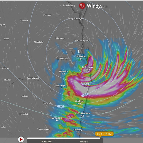
Total for the next 24 or so hours could be up to 300mm in some locations.

JTWC Update: 1pm Update
Cyclone Alfred Moving Towards Brisbane – Currently at 50 knots (93 km/h), Alfred is slowly heading westward and is expected to make landfall near Brisbane within 36-48 hours.
Weak Steering & Slow Movement – Due to weak atmospheric steering, Alfred's track has been irregular, which could delay its landfall and lead to prolonged severe weather impacts.
Strong Winds & Dangerous Seas – Wind gusts of up to 93 km/h and wave heights reaching 8 metres are affecting coastal areas, with damaging winds likely before landfall.
Weakening Before Landfall – Alfred is losing strength due to cooler waters and strong wind shear, with winds expected to drop to 40 knots (74 km/h) by the time it crosses the coast.
Prepare for Heavy Rain & Flooding – The system will bring heavy rain, strong winds, and potential flash flooding. Residents should stay indoors, secure property, and monitor warnings at bom.gov.au.

Temperature and Rainfall Forecast - Access-G

Friday, 7th March
Well, it seems like the temperatures will be reaching for the stars in the Channel Country, Maranoa and Warrego, Darling Downs and Granite Belt, and Wide Bay and Burnett districts. So, better pack some extra sunscreen and stay hydrated to avoid turning into a crispy critter.
Saturday, 8th March
Looks like we've got a mixed bag of weather coming our way, with rain, thunderstorms, damaging surf, and abnormally high tides making an appearance. And don't forget about those potentially destructive winds near Tropical Cyclone Alfred - sounds like a real party down there. In the southeast, temperatures will be below average, so be sure to break out your winter coats and scarves. But don't worry, if you're not a fan of the cold, the rest of the state will be enjoying above-average temperatures - lucky them! And for all you heat lovers out there, get ready for some severe heatwave conditions in the North Tropical Coast and Tablelands District. Time to break out the fans and stock up on ice cream - it's gonna be a scorcher! So, grab your umbrella, tie down your lawn furniture, and hold onto your hats - it's gonna be an interesting day weather-wise. Stay safe out there, folks!
Sunday, 9th March
Grab your raincoat and umbrella, folks! It's going to be a mixed bag out there today. In the far southwest, you can expect some clouds but not enough to ruin your day. Meanwhile, in the southeast, it's going to be raining cats and dogs with a side of thunderstorms. Keep an eye out for Ex-Tropical Cyclone Alfred - he might just crash the party with some heavy rainfall. Temperatures are playing a game of hide and seek, with below-average highs in the southeast, above-average temps in the far west, and everything else falling somewhere in between. So, whether you're dodging raindrops or soaking up the sun, make sure you dress accordingly and stay safe out there!
Monday, 10th March
For those of you in the far southwest, it'll be partly cloudy - because why be fully cloudy when you can be partially cloudy, right? Expect some isolated to scattered showers and maybe even a thunderstorm if you're lucky. In southeast Queensland, you might even get some localised moderate falls, so don't forget your umbrella. Temperatures will be above average in the west, near average in central and southeast Queensland, and just slightly below average in other areas. So basically, just another day in paradise.
Region Round-up - BOM
Forecast for North Tropical Coast and Tablelands:
Looks like we've got a classic case of partly cloudy skies today. There's a slight chance of a shower in the afternoon, so maybe bring an umbrella just in case. And watch out for those thunderstorms down south - they could be a real shocker. The winds will be light for most of the day, but they'll pick up to a breezy 15 to 20 km/h in the early afternoon before calming down again in the evening. Overnight temperatures will dip to a balmy 19 to 23 degrees, while daytime highs will hit the low to mid 30s. It's going to be a scorcher out there, folks. Don't forget your sunscreen, because the sun protection is at a moderate level from 8:30am to 4:20pm. The UV Index is predicted to reach a whopping 13, so be prepared for some extreme sun exposure. Stay safe out there, and maybe invest in a good hat and some sunglasses while you're at it.
Location | Icon | Min Temp (°C) | Max Temp (°C) | Description |
Cairns | ☀️ | 23 | 33 | Sunny. |
Atherton | ⛅ | 19 | 31 | Partly cloudy. |
Cooktown | ⛅ | 23 | 33 | Partly cloudy. |
Innisfail | ☀️ | 23 | 32 | Sunny. |
Mareeba | ⛅ | 21 | 34 | Partly cloudy. |
Forecast for Herbert and Lower Burdekin:
Looks like we've got a mixed bag of weather coming our way today. There's a slight chance of a shower inland, so if you're planning a picnic in the bush, you might want to pack an umbrella just in case. But don't worry, the rest of us can leave our raincoats at home because there's basically no chance of rain anywhere else. We might even get treated to a thunderstorm later in the morning, so if you're a fan of dramatic weather events, today might just be your lucky day. The winds will start off light but will pick up to a breezy north to northeasterly by the afternoon. Make sure you tie down your garden furniture or it might end up in your neighbor's yard. As for temperatures, it's going to be a warm one with daytime highs reaching the low to mid 30s. So if you were planning on wearing your winter coat, you might want to reconsider. And don't forget to slap on some sunscreen because the UV Index is predicted to reach a whopping 13, which is considered extreme. Sunburn is never a good look, folks.
Location | Min Temp (°C) | Max Temp (°C) | Description | |
Townsville | ⛅ | 25 | 32 | Mostly sunny. |
Ayr | ⛅ | 23 | 34 | Partly cloudy. |
Ingham | ⛅ | 23 | 35 | Partly cloudy. |
Forecast for Central Coast and Whitsundays:
Prepare for a day of meteorological mayhem with a mix of clouds and possible showers in the afternoon and evening. There's even a slight chance of a thunderstorm crashing the party in the late morning and afternoon. Winds will keep things interesting, starting off light then picking up to a northerly 15 to 20 km/h before calming down in the evening. As for temperatures, expect the overnight lows to dip into the low 20s while daytime highs will climb to the low to mid 30s. It's so hot, you might need a sun protection rating of 8:20am to 4:00pm to shield yourself from the UV Index predicted to reach a whopping 12 [Extreme]. So grab your sunscreen and brace yourself for a day that's sure to keep you on your toes!
Location | Icon | Min Temp (°C) | Max Temp (°C) | Description |
Mackay | ⛅ | 23 | 32 | Partly cloudy. |
Bowen | ⛅ | 24 | 33 | Mostly sunny. |
Forecast for Peninsula:
Prepare for a mix of clouds and possible showers up north near Weipa, with a slight chance of rain elsewhere. Thunderstorms may make an appearance as well. Winds will start off light but will pick up to 15-20 km/h from the northeast to southeast in the afternoon, before calming down at night. Temperatures will drop to the low to mid 20s overnight, while daytime temps will range from low to high 30s. Don't forget your sun protection from 8:40am to 4:40pm as the UV Index is expected to hit a whopping 14, classified as 'Extreme'.
Location | Icon | Min Temp (°C) | Max Temp (°C) | Description |
Weipa | 🌧 | 24 | 34 | Possible shower. |
Coen | ⛅ | 23 | 35 | Partly cloudy. |
Palmerville | ⛅ | 23 | 36 | Partly cloudy. |
Thursday Island | 🌧 | 25 | 31 | Shower or two. |
Forecast for Gulf Country:
Looks like we've got some interesting weather coming our way. There's a chance of showers, maybe even a thunderstorm later on. The winds will be blowing from the northwest to the northeast at a leisurely 15 to 20 km/h. As night falls, temperatures will drop to the mid to high 20s, while during the day, expect it to reach the mid to high 30s. Better slap on that sunblock from 8:50am to 4:40pm, as the UV Index is predicted to hit a whopping 13 [Extreme]. So, stay cool and protected out there, folks!
Location | Icon | Min Temp (°C) | Max Temp (°C) | Description |
Normanton | 🌧 | 26 | 35 | Shower or two. Possible storm. |
Burketown | 🌧 | 26 | 36 | Possible shower. |
Doomadgee | ⛅ | 26 | 37 | Partly cloudy. |
Kowanyama | 🌧 | 25 | 35 | Shower or two. |
Forecast for Northern Goldfields and Upper Flinders:
Looks like we've got a bit of a mixed bag today, folks. There's a good chance of showers hanging around the Gregory Ranges, but only a medium chance elsewhere. And hey, why not throw a thunderstorm into the mix for good measure? We'll start off with some light winds in the morning, which will then pick up to a north to northwesterly breeze of 15 to 20 km/h. Just when you're getting used to that, the winds will decide to take a break and become light in the middle of the day. Classic. Overnight temperatures will drop to the low to mid 20s, so you might want to crack a window open for some fresh air. Daytime temperatures will be hitting the low to mid 30s, so maybe leave the sweater at home. Don't forget your sunscreen, folks. Sun protection is recommended from 8:30am to 4:20pm, with a UV Index predicted to reach a whopping 13 [Extreme]. So slap on that SPF and enjoy the sunshine while it lasts!
Location | Icon | Min Temp (°C) | Max Temp (°C) | Description |
Charters Towers | ⛅ | 22 | 35 | Partly cloudy. |
Georgetown | 🌧 | 23 | 34 | Possible shower or storm. |
Forecast for Capricornia:
Well, it looks like we've got some sun peeking through today, with a slight chance of a shower making an appearance near the coast. Don't worry though, the rest of us are safe from the rain. Unless you're up north, then you might want to keep an eye out for a thunderstorm in the afternoon and evening. Winds will be doing their thing, coming from the west to southwesterly at a reasonable 20 to 30 km/h, before calming down to 15 to 25 km/h in the morning. Overnight, temperatures will drop to the low to mid 20s, so maybe grab an extra blanket. Daytime temperatures are set to rise to the mid to high 30s, so make sure you've got your sunscreen handy. Sun protection is advised from 8:20am to 3:50pm, with the UV Index predicted to hit a whopping 12. Extreme, right? So, slap on that sunscreen and stay cool out there, folks.
Location | Icon | Min Temp (°C) | Max Temp (°C) | Description |
Gladstone | ☀️ | 23 | 37 | Sunny. |
Rockhampton | ⛅ | 24 | 38 | Mostly sunny. |
Biloela | ☀️ | 21 | 38 | Sunny. |
Yeppoon | ⛅ | 24 | 35 | Partly cloudy. |
Forecast for Central Highlands and Coalfields:
Prepare yourself for a day of sunshine interrupted by a slight chance of rain in the northwest. Don't worry, the rest of us will remain dry as a bone. Keep an eye out for a possible thunderstorm up north - just to keep things interesting. Winds will be doing a little dance throughout the day, so be sure to hold onto your hats. Overnight, things will cool down to the low 20s, but don't get too comfortable because daytime temperatures are expected to soar into the mid to high 30s. Remember to slap on some sunscreen between 8:30am and 4:00pm - the UV Index is predicted to hit a whopping 12, so you might just burst into flames if you're not careful.
Location | Icon | Min Temp (°C) | Max Temp (°C) | Description |
Emerald | ⛅ | 24 | 38 | Partly cloudy. |
Clermont | ⛅ | 23 | 36 | Partly cloudy. |
Moranbah | ⛅ | 22 | 36 | Partly cloudy. |
Forecast for Central West:
Grab your sunscreen folks, it's going to be a scorcher out there! There's a teeny tiny chance of a shower up north, but don't count on it ruining your day anywhere else. Keep an eye out for thunderstorms in the morning - nothing like a little excitement to start your day. Winds will be all over the place, so hold onto your hats. Temperatures will be hot enough to fry an egg on the sidewalk, so stay hydrated and find some shade if you can. And don't forget your sunnies - that UV index is off the charts today. Stay cool out there!
Location | Icon | Min Temp (°C) | Max Temp (°C) | Description |
Longreach | ⛅ | 24 | 38 | Partly cloudy. |
Barcaldine | ⛅ | 24 | 38 | Partly cloudy. |
Winton | 🌧 | 24 | 38 | Possible storm. |
Forecast for North West:
Looks like Mt Isa might get a little sprinkle, but the rest of us can dust off our umbrellas and keep them in storage. There's a slight chance of a thunderstorm, so maybe bring a helmet just in case. Winds will be playing musical chairs throughout the day, so make sure your hat is securely fastened. Overnight, temperatures will plummet to the low to mid 20s, so maybe break out the winter pajamas. Daytime will be scorching hot, reaching around 40 degrees. Sunscreen is your best friend from 9:00am to 4:40pm, with the UV Index predicted to reach an extreme 13. So basically, you're going to feel like a roasted marshmallow by the end of the day. Enjoy!
Location | Icon | Min Temp (°C) | Max Temp (°C) | Description |
Mount Isa | ⛅ | 22 | 41 | Partly cloudy. |
Forecast for Channel Country:
Sunny with a side of thunderstorms up north for some added excitement. Winds blowing from the east to southeasterly at a decent clip of 25 to 35 km/h. Nighttime will bring relief with temperatures dropping to the mid to high 20s, but brace yourself for a scorching 40 degrees during the day. Sunscreen is your best friend from 9:00am to 4:40pm, as the UV Index is expected to hit a whopping 13, reaching extreme levels. So lather up and stay protected, unless you want to be mistaken for a lobster.
Location | Icon | Min Temp (°C) | Max Temp (°C) | Description |
Birdsville | ⛅ | 27 | 41 | Partly cloudy. |
Thargomindah | ☀️ | 27 | 38 | Sunny. |
Forecast for Maranoa and Warrego:
Looks like we're in for a scorcher today, folks! With winds deciding to do the hokey pokey from south to southeasterly and back again, you might want to hold onto your hats. Overnight, temperatures will dip down to the low to mid 20s, so you might want to crack open a window for some relief. Daytime temperatures will be reaching the mid to high 30s, so be sure to have your sunscreen handy from 8:30am to 4:00pm. The UV Index is predicted to reach a whopping 12, so you might want to consider wearing a hazmat suit just to be safe.
Location | Icon | Min Temp (°C) | Max Temp (°C) | Description |
Charleville | ☀️ | 23 | 37 | Sunny. |
Roma | ☀️ | 21 | 37 | Sunny. |
St George | ⛅ | 21 | 35 | Partly cloudy. |
Cunnamulla | ☀️ | 23 | 37 | Sunny. |
Forecast for Darling Downs and Granite Belt:
Looks like the weather is feeling a bit moody today, with a high chance of showers in the east and a medium chance everywhere else. Keep an eye out for possible thunderstorms in the southeast, and hold onto your hats because damaging winds could be making an appearance. Winds will be doing their own little dance today, starting off south to southwesterly and then switching to southerly before calming down in the evening. Overnight temperatures will be dropping to a somewhat bearable range of 19 to 22 degrees, while daytime temperatures will be hitting a high of 26 to 35 degrees. Don't forget your sunscreen, as the UV Index is predicted to reach an extreme level of 12. So grab your umbrella and sunscreen, and brace yourself for whatever Mother Nature decides to throw our way today!
Location | Icon | Min Temp (°C) | Max Temp (°C) | Description |
Dalby | 🌧 | 20 | 29 | Showers. Windy. |
Goondiwindi | 🌧 | 22 | 33 | Shower or two. |
Toowoomba | 🌩 | 19 | 24 | Rain. Very windy. |
Warwick | 🌩 | 19 | 23 | Rain. Very windy. |
Stanthorpe | 🌩 | 18 | 21 | Rain. Very windy. |
Forecast for Wide Bay and Burnett:
Looks like Mother Nature is feeling a little moody today. We've got some clouds floating around, a high chance of showers down south, and a slight chance of rain elsewhere. Oh, and don't forget the possibility of a thunderstorm with heavy falls or damaging wind gusts - just to keep things interesting. Winds will be doing their thing, blowing west to southwesterly at speeds of 45 to 65 km/h, but don't worry, they'll calm down a bit as the day goes on. Temperatures will be dropping overnight to a balmy 19 to 23 degrees, with daytime temps reaching a scorching 28 to 36 degrees. Make sure you slap on that sunblock between 8:10am and 3:50pm, because the UV Index is predicted to reach a whopping 11 - that's Extreme with a capital E. So, grab your umbrella and hold onto your hat, it's going to be a wild ride out there.
Location | Icon | Min Temp (°C) | Max Temp (°C) | Description |
Bundaberg | 🌩 | 23 | 36 | Wind easing. Partly cloudy. |
Gympie | 🌩 | 22 | 31 | Windy. Showers. |
Hervey Bay | 🌧 | 23 | 33 | Shower or two. Windy. |
Kingaroy | 🌩 | 20 | 28 | Showers. Very windy. |
Maryborough | 🌩 | 22 | 33 | Shower or two. Very windy. |
Gayndah | 🌧 | 22 | 35 | Possible shower. Wind easing. |
Forecast for Southeast Coast:
Looks like Mother Nature is feeling a bit moody today, with a very high chance of rain and even the possibility of a thunderstorm. Heavy rain might cause some flash flooding, especially in the south and along the coast. And hold onto your hats, because we could be in for some destructive wind gusts that could exceed 130 km/h thanks to Tropical Cyclone Alfred. Overnight temperatures will drop to the balmy range of 19 to 22 degrees, with daytime temperatures creeping up into the mid to high 20s. But if you were planning on hitting the beach, you might want to think again. The surf is going to be large and powerful, making it hazardous for activities like rock fishing, swimming, and surfing. Don't forget your sunscreen though, because even with all this rain and wind, the UV Index is predicted to reach a whopping 12, which is classified as "Extreme." So slap on that sun protection between 8:10am and 3:40pm if you want to avoid looking like a lobster.
Location | Icon | Min Temp (°C) | Max Temp (°C) | Description |
Beaudesert | 🌨 | 20 | 25 | Cyclone expected. |
Brisbane | 🌨 | 22 | 25 | Cyclone expected. |
Gatton | 🌨 | 21 | 28 | Cyclone possible. |
Ipswich | 🌨 | 21 | 26 | Cyclone expected. |
Logan Central | 🌨 | 20 | 25 | Cyclone expected. |
Maroochydore | 🌨 | 23 | 29 | Cyclone possible. |
Redcliffe | 🌨 | 22 | 25 | Cyclone possible. |
Surfers Paradise | 🌨 | 20 | 25 | Cyclone expected. |
We run on positivity and our output is education for your peace of mind. Wally also runs on coffee so shout him a coffee today, just for for $5 each year, or one each month for a year for $55 https://wallysweather.com.au/community
National maps by Weatherzone (weatherzone.com.au)
State maps by Windy (Windy.com)
Weather forecast supplemented by Bureau of Meteorology (bom.gov.au)
Rainfall daily totals (https://meteologix.com/ )
AccuWeather (https://www.accuweather.com/)
Nine Weather (https://www.9news.com.au/weather)
Wally's Weather provides professionally researched data and information. Andrew aka 'Wally' has over 20 years of experience in meteorology research and data analysis. In 2023 finished top 4 for the AMOS national weather forecasting competition. The content here is provided as educational information aimed at providing the community and businesses with the tools required to determine local-based forecasts. IMPORTANT: The forecasts and information posted should never be used on their own to make business decisions as local influences.
コメント