

Colour your Daily Forecast - Mar 6 - Wally's Weather Australia
- Mar 4
- 18 min read
Updated: Mar 5
We're thrilled to welcome Painting Professionals as our Leading Sponsor for the next 8 months, Daily, Monthly and Long Range Forecast!

We specialise in being the best of the best period.
The old saying "you get what you pay for".
We definitely aren't the cheapest and don't claim to be.
But if you want the best quality, with the best quality paints, backed with a 12 year year warranty!
Then get in contact with the team and see what we can do for you.
SPECIAL OFFER
15% discount for all wally members. And 15% discount for all ADF and emergency service personnel.
Ph +61 417 065 781
National Synoptic Situation
National Temperature and Rainfall

Rain typically refers to steady, continuous precipitation that lasts for a longer period, sometimes hours or even days. It can vary in intensity, but it's usually more consistent and widespread.
Showers, on the other hand, are shorter bursts of rain, often intermittent. They can be heavy but usually don't last long. Showers are more sporadic and may be followed by dry periods or other types of weather, like sun or clouds.
National Synoptic Situation
QLD:
Tropical Cyclone Alfred is on the move towards the southeast coast, bringing with it some severe coastal hazards near Sandy Cape. This cyclone is expected to make landfall on Friday morning, losing steam as it moves inland and eventually fizzling out by the weekend. Meanwhile, a weak trough will be hanging out in the western and central interior for a while. Come Saturday, a ridge will be making its way over eastern Queensland thanks to a high sauntering across the Tasman Sea, bringing some extra moisture to the northeast coast. So, keep an eye out for those hazards and stay prepared as the weather decides to throw us a curveball or two.
NSW and ACT:
Looks like Mother Nature is feeling a bit indecisive this week, with high pressure systems doing the limbo to the south while a broad trough hangs out in the western inland. This means we'll be stuck in an easterly airstream with not much changing today and Thursday. Oh, and let's not forget our uninvited guest, Tropical Cyclone Alfred, crashing the party off the coast and bringing heavy rain, damaging winds, and some gnarly surf along the way. After its dramatic entrance, the cyclone core is expected to take a road trip inland, spreading wet conditions to central, eastern, and southern parts of the state. So, get those umbrellas and rain boots ready, folks!
VIC:
Get ready for a rollercoaster of weather this week in Victoria! A weak low pressure trough is making its way across central Victoria, followed by a cooler southerly airstream in the south on Thursday. But wait, there's more! By Friday and Saturday, warm east to northeasterly winds will be blowing as a high pressure system moves in. And just when you thought it couldn't get any crazier, a low pressure trough and remnants of tropical cyclone Alfred are set to shake things up on Sunday. Time to batten down the hatches and hold onto your hats, folks!
SA:
So, it looks like we've got some high pressure moving in from the south on Wednesday, making its way east of Tasmania by Friday. This high will bring along a nice ridge over the waters south of SA on Saturday. But wait, there's more! Another high will be making its way over from the west on Sunday and early next week. Meanwhile, up north in SA, we've got a broad area of low pressure developing over the weekend and sticking around into early next week. Mother Nature sure knows how to keep things interesting, doesn't she? So, get ready for some fluctuating weather patterns in the days ahead!
WA:
Prepare for some trough action near the Pilbara coast and southern Kimberley. Watch as the trough takes a leisurely stroll offshore in the mornings, while a high pressure ridge flexes its muscles to the south, sending breezy southeasterly winds our way. It's like a weather dance, but with more science.
TAS:
So, looks like we've got a little cold front coming in from the west today, followed by some high pressure on Thursday. The high centre will be making its grand entrance on Friday, then gallivanting over to the Tasman Sea for the weekend, bringing us some warm northerly winds. But hold onto your hats, because a trough is sneaking in late Sunday to shake things up a bit. Just your typical weather rollercoaster ride, folks!
NT:
So, we've got a weak ridge up north causing some scattered showers and thunderstorms. But fear not, it's expected to weaken even more by the end of the week, giving us more of that lovely precipitation we all know and love. There's a trough hanging out in the Tanami and Barkly Districts, just chillin' and doing its thing. And to make things even more interesting, a high is moving east and a new trough is forming over in WA. So basically, expect more wet stuff coming our way soon. Time to bust out those umbrellas and rain boots, folks!
National Weather Warnings
New South Wales
Victoria
Queensland
Western Australia
South Australia
Tasmania
Northern Territory
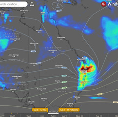
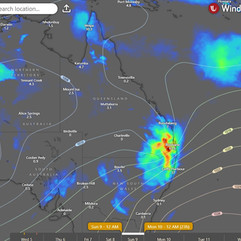
National Storms and Rain Accumulation outlook


Four Day Forecasts
If you run a business and would like the benefits of a Big Shout plus your business promoted for 365 days, head here to take out a Bold Shout for $250.


NQ Rainfall 24 Accumulated (ACCESS G) PLUS one day


Monsoon Update
If you have or had a Big Shout, make sure you keep your card updated. Login, select Profile, Select Wallet and update your details https://wallysweather.com.au
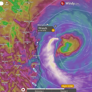
Current details on TC Alfred:

Looking at the next 24 hours, what can you expect?
Well with TC Alfred 300km from Brisbane to the centre of the system, there is still a lot of time to wait before things begin to pick up. In spite of those sites promoting a "feeling" that it will be a cat 3, I prefer to use the data.
So there will be a gradual increase in average wind speed through till about midday tomorrow and then the big gusts will start to come through. But the average winds will still feel reasonably low, it will still be gusty. Then by about 4pm the biggest gusts are expected around 120km/h or less. But this will mainly be along the islands in front that protect the greater Brisbane area. The Gold Coast will see more of the higher gusts and the mountains should experience the acceleration up the mountains, anabatic winds.

I am using the ACCESS C model for Brisbane below which from the recent floods in the NQ performed really well compared to any other. It is a forecast specifically for the Brisbane region. And the NQ has one for them as well.
So keep your eye on the movement, things can change quickly but in spite of what people think, this has been a very predictable system. It's just the spaghetti model mr squiggles of the community that made it seem like it was all over the place.


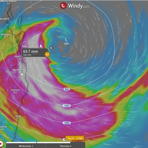
There will be occasional bands of rain roll through from the SE starting around Coffs Harbour and moving North then back out to sea. Midday to mid afternoon the rain will become steady and heavy at around 10 to 30mm per hour (the numbers on the map are 3 hourly for the right map. Left map is the next 24 to 36 hours accumulated.
As has been stated over and over, it's not so much the wind, because the Islands will protect most of Brisbane, and the Gold Coast will see most of the strong wind gusts, but it is the rain and storm surge that will be the main issue.
As far as wind goes, do not tie things down and use pegs, they will become dangerous projectiles. Weight things down with water or other objects one person cannot move, or put them inside. Do not put gas bottles inside but a Webber Q can go in, we put ours in. You still have time tomorrow to clean up. And don't feel so let down if you are in an area that doesn't get much wind, because some people will be lucky, some won't be.


Current swell is greater to the North near the Sunny Coast and Moreton Bay and Straddy. It is expected to decrease from now (Factor in the tide though) but the waves will increase but mainly around the Gold Coast.
I noted people are staying, stating there is nowhere to go. The issue is that any problems, and the emergency services are put at risk. Please consider the emergency services whom have already lost lives this year performing emergency duties.


JTWC Update: 1pm Update
Tropical Cyclone Alfred, a category 2 system with winds up to 55 knots (100 km/h), is tracking west towards Brisbane, with landfall expected late Thursday or early Friday. The cyclone is maintaining strength but may slightly intensify before crossing the coast. Heavy rain, damaging winds, and dangerous storm surges could impact southeast Queensland and northeast New South Wales, leading to flash flooding and coastal inundation. Residents should secure property, stay indoors during severe weather, and follow emergency warnings at bom.gov.au.

Temperature and Rainfall Forecast - Access-G

Thursday, 6th March
Well, it seems like playing with matches in the Channel Country and southeastern Queensland isn't the best idea today. So, maybe hold off on your bonfire plans and opt for a safer activity like knitting or organizing your sock drawer instead. Just a friendly reminder to not add "arsonist" to your list of hobbies.
Friday, 7th March
Looks like we've got a mixed bag of weather today. Rain and showers in the southeast, along with some isolated thunderstorms bringing heavy rainfall - so maybe bring an umbrella if you don't want to be swimming to work. Southwest is looking partly cloudy, while the rest of us might see some scattered showers and the occasional thunderstorm north of Blackall. Watch out for some damaging surf and abnormally high tides down south - might want to hold off on that beach day. And keep an eye out for possible damaging wind gusts, especially in the southeast - maybe tie down your lawn furniture just in case. Temperatures will be below average in the southeast, but above average elsewhere. And if you're in the Capricornia, North Tropical Coast, Tablelands, or Herbert and Lower Burdekin Districts, you'll be dealing with some severe heatwave conditions - so maybe crank up the AC and stay hydrated. Stay safe out there, folks!
Saturday, 8th March
Grab your umbrellas and galoshes, because the southeast is about to get a good soaking with scattered rain and showers, and maybe even a thunderstorm or two. Don't forget your sunscreen though, as the rest of the region will be enjoying some above-average temperatures. And if you happen to find yourself in the North Tropical Coast and Tablelands District, be prepared for some serious heatwave conditions - it's going to be a scorcher!
Sunday, 9th March
Grab your umbrella and sunscreen, folks! The weather gods are feeling indecisive today. Expect some scattered showers and isolated thunderstorms in the southeast, so make sure to bring a raincoat. Maximum temperatures will be below average in the southeast but above average in the far west, so dress accordingly. And as for the far southwest, well, it looks like you'll just have to deal with some partly cloudy skies. Mother nature sure has a sense of humour, doesn't she?
Region Round-up - BOM
Forecast for North Tropical Coast and Tablelands:
Get your sunscreen ready, folks! It's going to be mostly sunny with a slight chance of a shower inland - so if you're planning a picnic, maybe bring an umbrella just in case. Don't worry about rain anywhere else though, it's basically a desert out there. Oh, except for the south - they might get a thunderstorm, but hey, at least it'll cool things down a bit. Light winds will be dancing around, starting off northeast then switching to southeasterly before finally giving up and becoming light by the evening. Temperatures will be dropping overnight to a balmy 18 to 23 degrees, while daytime highs will reach the low to mid 30s. Don't forget your sun protection from 8:30am to 4:20pm - the UV Index is predicted to hit a whopping 13, so unless you want to resemble a lobster, lather up!
Location | Icon | Min Temp (°C) | Max Temp (°C) | Description |
Cairns | ☀️ | 23 | 33 | Sunny. |
Atherton | ⛅ | 18 | 31 | Partly cloudy. |
Cooktown | ☀️ | 24 | 33 | Sunny. |
Innisfail | ☀️ | 22 | 32 | Sunny. |
Mareeba | ⛅ | 19 | 34 | Partly cloudy. |
Forecast for Herbert and Lower Burdekin:
Prepare for a day of unpredictable weather with a mix of clouds and potential showers. There's a slim chance of getting caught in a downpour in the afternoon or evening, so bring an umbrella just in case. Watch out for thunderstorms rolling in from inland later in the morning - a light breeze might not be enough to save you from getting soaked. Expect temperatures to drop to the low to mid 20s overnight, but soar to a scorching 32 to 37 during the day. Don't forget your sunscreen, as the UV Index is expected to reach an extreme 13 - unless you're aiming for that lobster look, of course.
Location | Icon | Min Temp (°C) | Max Temp (°C) | Description |
Townsville | ☀️ | 25 | 32 | Sunny. |
Ayr | ☀️ | 24 | 34 | Sunny. |
Ingham | ⛅ | 22 | 34 | Mostly sunny. |
Forecast for Central Coast and Whitsundays:
Well, it looks like Mother Nature might throw a little surprise shower our way this afternoon and evening. So, be sure to pack an umbrella just in case. Don't worry, the winds will be light enough to keep your hair in place. Overnight, temperatures will drop to the low 20s, so you might want to grab an extra blanket. And don't forget your sunscreen, folks, because the UV index is predicted to reach a whopping 13 - that's extreme! So, get ready to slather on that sun protection from 8:20am to 4:00pm. Stay safe out there!
Location | Icon | Min Temp (°C) | Max Temp (°C) | Description |
Mackay | ⛅ | 23 | 32 | Partly cloudy. |
Bowen | ⛅ | 24 | 32 | Mostly sunny. |
Forecast for Peninsula:
Well, it looks like we might have some showers up north near Weipa, but don't worry, there's only a slight chance anywhere else. Oh, and watch out for thunderstorms - always a fun surprise. Expect light winds in the morning, then they'll become easterly before giving up entirely in the evening. Temperatures will drop to the low to mid 20s overnight, but don't get too comfortable because they'll shoot back up to the low to high 30s during the day. Remember your sun protection from 8:40am to 4:40pm, because the UV Index is predicted to reach a whopping 14 - that's extreme, folks.
Location | Icon | Min Temp (°C) | Max Temp (°C) | Description |
Weipa | 🌧 | 24 | 35 | Shower or two. |
Coen | ⛅ | 24 | 35 | Partly cloudy. |
Palmerville | ⛅ | 22 | 37 | Mostly sunny. |
Thursday Island | 🌧 | 26 | 31 | Shower or two. |
Forecast for Gulf Country:
Prepare yourself for a mix of sun and clouds today, with a slight possibility of rain later on. Don't be surprised if you hear a rumble of thunder in the distance. Winds will be light in the morning, but will pick up to a moderate 15 to 20 km/h from the northwest to northeast. As the day progresses, temperatures will soar to a scorching 35 to 40 degrees. Remember to slap on some sunblock between 8:50am and 4:40pm, as the UV Index is expected to hit a whopping 13, classified as "Extreme". Stay cool out there!
Location | Icon | Min Temp (°C) | Max Temp (°C) | Description |
Normanton | 🌧 | 27 | 35 | Shower or two. Possible storm. |
Burketown | 🌧 | 27 | 38 | Sunny morning. Possible storm. |
Doomadgee | 🌧 | 26 | 38 | Sunny morning. Possible storm. |
Kowanyama | ⛅ | 25 | 36 | Partly cloudy. |
Forecast for Northern Goldfields and Upper Flinders:
Prepare for some moody skies today, with a sprinkle or two possibly crashing the party in the afternoon and evening. Keep an eye out for a thunderstorm that might make an appearance in the late morning - Mother Nature loves to keep us on our toes! Winds will be playing a game of musical chairs throughout the day, so hold onto your hats. Temperatures will be dropping to the low to mid 20s overnight, but don't get too comfortable - we're looking at a scorching 34 to 39 degrees during the day. Remember to slap on that sunscreen from 8:30am to 4:20pm, as the UV Index is predicted to reach a whopping 13 [Extreme]. Stay cool, folks!
Location | Icon | Min Temp (°C) | Max Temp (°C) | Description |
Charters Towers | ⛅ | 22 | 37 | Partly cloudy. |
Georgetown | 🌧 | 24 | 36 | Shower or two. Possible storm. |
Forecast for Capricornia:
Well, it looks like we'll be experiencing a bit of a mixed bag today. Expect mostly sunny skies with a slight chance of a shower thrown in for good measure. Don't be surprised if you feel like you're in the middle of a wind tunnel, as southwesterly winds of 20 to 30 km/h are on the horizon. Overnight, temperatures will drop to the low 20s, giving us a bit of relief from the scorching daytime heat. Speaking of which, get ready to sweat it out as temperatures are expected to reach the mid to high 30s. Make sure to slap on some sunscreen between 8:20am and 4:00pm to avoid turning into a lobster, as the UV Index is predicted to reach a whopping 12 [Extreme]. Time to break out the big guns, folks!
Location | Icon | Min Temp (°C) | Max Temp (°C) | Description |
Gladstone | ⛅ | 24 | 36 | Partly cloudy. |
Rockhampton | ⛅ | 23 | 37 | Mostly sunny. |
Biloela | ⛅ | 21 | 37 | Mostly sunny. |
Yeppoon | ⛅ | 24 | 34 | Mostly sunny. |
Forecast for Central Highlands and Coalfields:
Looks like we've got a little bit of everything in store for us today. From sunny skies to a slight chance of a shower, with a possibility of a thunderstorm in the northwest later on. Winds will be coming at us from all directions, so hold onto your hats. Overnight temperatures will dip down into the low 20s, while daytime temperatures will be climbing up into the mid to high 30s. Make sure to slather on that sunblock between 8:20am and 4:00pm, because the UV Index is predicted to reach a whopping 13. So, stay cool, stay dry, and don't forget your umbrella just in case!
Location | Icon | Min Temp (°C) | Max Temp (°C) | Description |
Emerald | ⛅ | 23 | 37 | Mostly sunny. |
Clermont | ⛅ | 23 | 36 | Mostly sunny. |
Moranbah | ⛅ | 23 | 35 | Partly cloudy. |
Forecast for Central West:
Expect a touch of cloud cover today, with a sprinkle of rain possible up in the northeast, just for fun. Don't hold your breath for any precipitation elsewhere - it's as likely as finding a unicorn in your backyard. There's even a chance of a thunderstorm to really spice things up. Wind will be playing musical chairs, switching from northeast to southeasterly, then southeast to southwesterly, and finally settling on northeast to southeasterly by evening. Overnight, temperatures will drop to the low to mid 20s, so you might actually get to sleep without sweating buckets. Daytime highs will hit around 40, so maybe consider investing in a portable fan or a personal ice bath. Sun protection is no joke, folks - slap on that SPF from 8:40am to 4:30pm. The UV Index is predicted to reach a whopping 12, so you might want to cover yourself head to toe in titanium just to be safe.
Location | Icon | Min Temp (°C) | Max Temp (°C) | Description |
Longreach | ⛅ | 24 | 38 | Partly cloudy. |
Barcaldine | ⛅ | 24 | 38 | Partly cloudy. |
Winton | ⛅ | 25 | 41 | Partly cloudy. |
Forecast for North West:
Looks like we've got a classic case of "mostly sunny with a slight chance of a shower" in the northeast today. Don't worry though, the rest of us can enjoy a near zero chance of rain. Just a heads up, there's a slight chance of a thunderstorm in the afternoon and evening, so maybe bring an umbrella just in case. Winds will be all over the place, starting off northwest to northeasterly before doing a little dance and ending up southeast to southwesterly by the late afternoon. Overnight temperatures will drop to the mid to high 20s, while daytime temperatures will soar to the low 40s. Better break out the sunscreen, because we've got a UV Index predicted to reach 13 [Extreme] from 9:00am to 4:40pm. Stay cool out there!
Location | Icon | Min Temp (°C) | Max Temp (°C) | Description |
Mount Isa | ☀️ | 23 | 42 | Sunny. |
Forecast for Channel Country:
Well, looks like we're in for a scorcher today. Time to break out the sunscreen and maybe consider investing in a portable air conditioner. The winds will be coming in from the southeast at a brisk 25 to 35 km/h, so hold onto your hats. Overnight, it'll cool down to the mid to high 20s, but don't get too comfortable because daytime temperatures will be hitting around 40 degrees. Make sure to stay indoors during the peak sun hours from 9:00am to 4:40pm, as the UV Index is predicted to reach a whopping 12, which is considered extreme. So, get ready to sweat it out and maybe start planning that trip to Antarctica.
Location | Icon | Min Temp (°C) | Max Temp (°C) | Description |
Birdsville | ☀️ | 28 | 41 | Sunny. |
Thargomindah | ⛅ | 26 | 38 | Mostly sunny. |
Forecast for Maranoa and Warrego:
Grab your sunglasses and sunscreen, folks! It's going to be mostly sunny with just a slight chance of a shower in the southeast. Don't worry, the rest of us will be bone dry. There's even a slim chance of a thunderstorm for those lucky enough to be in the southeast. Winds will be coming in from the southeast at a breezy 20 to 30 km/h. Overnight, temperatures will drop to the low to mid 20s, so maybe crack open a window before bed. Daytime temperatures will be scorching, reaching the mid to high 30s. Make sure to slap on some sun protection from 8:20am to 4:00pm, as the UV Index is predicted to reach a whopping 12 [Extreme]. Stay cool out there, and remember to stay hydrated!
Location | Icon | Min Temp (°C) | Max Temp (°C) | Description |
Charleville | ⛅ | 22 | 36 | Partly cloudy. |
Roma | ☀️ | 21 | 36 | Sunny. |
St George | ⛅ | 21 | 35 | Partly cloudy. |
Cunnamulla | ⛅ | 23 | 36 | Mostly sunny. |
Forecast for Darling Downs and Granite Belt:
Grab your raincoat and umbrella, folks! We have a very high chance of showers in the Granite Belt and the east, and a medium chance everywhere else. Don't be surprised if you hear some thunder rumbling in the background. Hold onto your hats because we have southerly winds blowing at a speedy 40 to 60 km/h. Overnight, temperatures will drop to a balmy 19 to 22 degrees, while daytime temperatures will soar to a scorching 28 to 36 degrees. Make sure to slather on that sunscreen from 8:10am to 3:50pm, as the UV Index is predicted to reach a whopping 12 (Extreme). Stay dry and stay cool out there!
Location | Icon | Min Temp (°C) | Max Temp (°C) | Description |
Dalby | 🌧 | 20 | 30 | Shower or two. Windy. |
Goondiwindi | 🌧 | 22 | 36 | Shower or two. |
Toowoomba | 🌩 | 20 | 25 | Showers. Very windy. |
Warwick | 🌧 | 19 | 27 | Rain. Very windy. |
Stanthorpe | 🌧 | 19 | 23 | Rain. Very windy. |
Forecast for Wide Bay and Burnett:
Get ready for some classic Australian weather - partly cloudy with a chance of showers, especially in the late morning and afternoon. Don't be surprised if you hear some thunder rumbling down south. And hold onto your hats, because we've got some strong southwesterly winds blowing at 40 to 60 km/h. As for temperatures, expect a cool night with lows in the low 20s, but things will heat up during the day with highs reaching 28 to 34. So, make sure you dress accordingly to avoid any unexpected sweat stains. If you're planning on hitting the beach, be cautious of the large and powerful surf conditions. It's not just for show - it can be dangerous for activities like rock fishing, swimming, and surfing. Remember, safety first! And don't forget your sunscreen, because the sun protection is high from 8:10am to 3:50pm. The UV Index is predicted to reach a whopping 12, which is considered extreme. So, lather up and protect yourself from that scorching Aussie sun.
Location | Icon | Min Temp (°C) | Max Temp (°C) | Description |
Bundaberg | 🌧 | 23 | 33 | Shower or two. Wind easing. |
Gympie | 🌩 | 23 | 31 | Very windy. Shower or two. |
Hervey Bay | 🌧 | 23 | 32 | Shower or two. Windy. |
Kingaroy | 🌩 | 20 | 28 | Shower or two. Very windy. |
Maryborough | 🌧 | 23 | 33 | Shower or two. Windy. |
Gayndah | 🌧 | 22 | 33 | Possible shower. Wind easing. |
Forecast for Southeast Coast:
Looks like Mother Nature is feeling a bit moody today. There's a very high chance of rain, so you might want to grab your umbrella and your ark just in case. Oh, and don't forget your floaties because there's also a chance of a thunderstorm. If you're in the south, be prepared for some heavy falls - and I'm not talking about clumsy people tripping over. We're talking rain here, folks. And hold onto your hats because there could be some destructive wind gusts blowing through, reaching speeds over 130 km/h. Overnight temperatures will be dropping to a balmy 19-22 degrees, so maybe pull out that extra blanket you've been hiding away. Daytime temperatures will be in the mid to high 20s, so you might want to layer up and then shed those layers as the day goes on. And if you were planning on hitting the beach, think again. The surf conditions are going to be large and powerful, which is just a fancy way of saying dangerous. So maybe skip the rock fishing, swimming, and surfing today unless you're a professional daredevil. Oh, and don't forget your sunscreen. The UV Index is predicted to reach a whopping 12, which is extreme. So unless you want to end up looking like a lobster, slap on that sun protection from 8:10am to 3:50pm. Stay safe out there, folks. Mother Nature waits for no one.
Location | Icon | Min Temp (°C) | Max Temp (°C) | Description |
Beaudesert | 🌨 | 21 | 28 | Cyclone expected. |
Brisbane | 🌨 | 22 | 29 | Cyclone expected. |
Gatton | 🌧 | 21 | 30 | Rain increasing. Very windy. |
Ipswich | 🌨 | 21 | 29 | Cyclone expected. |
Logan Central | 🌨 | 21 | 28 | Cyclone expected. |
Maroochydore | 🌨 | 23 | 29 | Cyclone possible. |
Redcliffe | 🌨 | 22 | 28 | Cyclone expected. |
Surfers Paradise | 🌨 | 21 | 27 | Cyclone expected. |
We run on positivity and our output is education for your peace of mind. Wally also runs on coffee so shout him a coffee today, just for for $5 each year, or one each month for a year for $55 https://wallysweather.com.au/community
National maps by Weatherzone (weatherzone.com.au)
State maps by Windy (Windy.com)
Weather forecast supplemented by Bureau of Meteorology (bom.gov.au)
Rainfall daily totals (https://meteologix.com/ )
AccuWeather (https://www.accuweather.com/)
Nine Weather (https://www.9news.com.au/weather)
Wally's Weather provides professionally researched data and information. Andrew aka 'Wally' has over 20 years of experience in meteorology research and data analysis. In 2023 finished top 4 for the AMOS national weather forecasting competition. The content here is provided as educational information aimed at providing the community and businesses with the tools required to determine local-based forecasts. IMPORTANT: The forecasts and information posted should never be used on their own to make business decisions as local influences.


Komentarze