Colour your Daily Forecast - Mar 11 - Wally's Weather Australia
- Mar 4
- 16 min read
We're thrilled to welcome Painting Professionals as our Leading Sponsor for the next 8 months, Daily, Monthly and Long Range Forecast!

We specialise in being the best of the best period.
The old saying "you get what you pay for".
We definitely aren't the cheapest and don't claim to be.
But if you want the best quality, with the best quality paints, backed with a 12 year year warranty!
Then get in contact with the team and see what we can do for you.
SPECIAL OFFER
15% discount for all wally members. And 15% discount for all ADF and emergency service personnel.
Ph +61 417 065 781
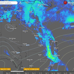
National Synoptic Situation
National Temperature and Rainfall

Rain typically refers to steady, continuous precipitation that lasts for a longer period, sometimes hours or even days. It can vary in intensity, but it's usually more consistent and widespread.
Showers, on the other hand, are shorter bursts of rain, often intermittent. They can be heavy but usually don't last long. Showers are more sporadic and may be followed by dry periods or other types of weather, like sun or clouds.
National Synoptic Situation
QLD:
Well, it looks like Ex-Tropical Cyclone Alfred has thrown in the towel and decided to join forces with a trough in southern Queensland. This dynamic duo is now making their way through western and southern Queensland into New South Wales. On the other side of the ring, we have a ridge hanging out over eastern Queensland, getting ready to flex its muscles on Thursday as a new high moves into the Tasman Sea. This high will then do some heavy lifting and push the trough west into central Australia. The ridge will then take over the spotlight and show off its strength over most of the state into the weekend. So buckle up, Queensland, it's going to be a wild ride!
NSW and ACT:
So, here's the scoop on the weather for the next few days: there's a trough hanging out up north, just chilling and slowly making its way westward. Meanwhile, a high pressure ridge is holding things down in the rest of the state. A cold front is going to give the southern part of the state a little brush, and its buddy trough will be crossing the southern inland by Wednesday and Thursday. This dynamic duo will kick that ridge to the northeast and bring in a nice southerly change by Thursday. So, buckle up and get ready for some weather shenanigans!
VIC:
Well, it looks like we've got a high pressure system playing babysitter to a low pressure system in the southwest of Tasmania. This dynamic duo is bringing us some warm and sticky easterly winds. The high is set to ditch Tasmania for greener pastures to the south on Tuesday, while its low pressure buddy saunters over to western Victoria. Wednesday will be a slow dance as the trough leisurely crosses the state, followed by another high making its way across the southern waters. By Thursday night, the high will cozy up near western Bass Strait, before giving us a warm hug with northerly winds on Friday as it heads over to the Tasman Sea. So, make sure to embrace those warmer winds and maybe break out the sunscreen, because it's going to be a toasty end to the week.
SA:
So, it looks like we've got a low pressure trough making its way across the west of SA, taking its sweet time as it heads east. Meanwhile, a high pressure system is going to set up shop south of the Bight on Wednesday, pushing that trough over to the eastern states. By Friday, the high will be chilling out over the Tasman Sea like it's on vacation. But don't get too comfortable, because a low pressure trough is gearing up to crash the party from the west over the weekend. Looks like Mother Nature is playing a game of weather ping pong with us this week!
WA:
Looks like we've got a big ol' trough hangin' out up north. It's gonna stick around for a bit, so better bring an umbrella if you're in that neck of the woods. Just a heads-up, folks.
TAS:
Well, it looks like Tasmania is in for a bit of a weather rollercoaster this week. A trough will be making its way eastward tonight, followed by a high pressure system sneaking in from the south on Tuesday. But hold on to your hats, because a low pressure system will be crashing the party from the west on Wednesday, bringing along a cold front for added drama. Don't worry though, another high pressure system will come to the rescue on Thursday evening, chilling out to the northeast by Friday. Mother nature sure knows how to keep us on our toes!
NT:
So, it seems like we've got a big ol' blob of low pressure hanging out in the Northern Territory, along with a trough making its way through the southern parts. Just your typical weather pattern causing some mischief. Time to break out the umbrellas and weather-proof attire, folks!
National Weather Warnings
New South Wales
Victoria
Queensland
Western Australia
South Australia
Tasmania
Northern Territory
No warnings available at this time for Northern Territory.
National Storms and Rain Accumulation outlook


Four Day Forecasts
If you run a business and would like the benefits of a Big Shout plus your business promoted for 365 days, head here to take out a Bold Shout for $250.


NQ Rainfall 24 Accumulated (ACCESS G) PLUS one day


Temperature and Rainfall Forecast - Access-G

Tuesday, 11th March
Grab your sunglasses and raincoat because we've got a mixed bag of weather coming your way. In the far southwest, expect mostly sunny skies - perfect for a leisurely stroll or a dramatic sunglasses selfie. Everywhere else, you might encounter some isolated to scattered showers and thunderstorms. If you're in the southern interior, keep an eye out for possible severe thunderstorms that could bring heavy rainfall and damaging wind gusts - a great excuse to stay indoors and binge-watch your favorite TV show. Don't let the light to moderate northeast to southeasterly winds catch you off guard, as they'll be turning northwest to northeasterly in central and northern Queensland during the morning and early afternoon. And if you're wondering about temperatures, they'll be above average inland through the tropics and in the far west, while staying near average elsewhere. So whether you're soaking up the sun in the far southwest or dodging thunderstorms elsewhere, just remember to dress accordingly and keep an eye on the sky.
Wednesday, 12th March
Grab your umbrella and sunscreen, folks! You might want to keep an eye out for isolated to scattered showers and thunderstorms up north and out west in Queensland. Don't be surprised if you encounter some isolated showers in the southeast and along the Central Coast. And don't forget, it's going to be a bit warmer than usual in the southwest, but just about average everywhere else. Stay dry and stay cool out there!
Thursday, 13th March
Pack your umbrella if you're heading towards the east of Rockhampton, where isolated showers are expected. As for the rest of the state, you might want to bring your raincoat too, as scattered showers and even a thunderstorm or two could make an appearance. Temperatures will be on the warmer side in the far southwest, but don't worry, you won't need to break a sweat elsewhere. Just another day in the unpredictable world of Australian weather!
Friday, 14th March
Looks like some parts of the state will have some clouds and possibly some rain. You might want to pack an umbrella just in case. Watch out for thunderstorms up north and in the northwest - Mother Nature is feeling a little feisty today. Temperatures will be higher in the southwest, so maybe plan a BBQ there. Stay dry, folks!
Region Round-up - BOM
Forecast for North Tropical Coast and Tablelands:
Get your umbrellas and sunscreen ready, folks! It's going to be a partly cloudy day with a medium chance of showers, especially in the late morning and afternoon. There's even a possibility of a thunderstorm, so you might want to stay indoors if you're not a fan of lightning shows. Light winds will start off in the morning but will calm down by the evening, so hold onto your hats. Overnight temperatures will drop to a somewhat bearable 20 to 25 degrees, while daytime temperatures will reach a scorching 28 to 33 degrees. Sun protection is a must from 8:30am to 4:20pm, as the UV Index is predicted to reach a whopping 13 (Extreme). So, slap on that sunscreen and stay hydrated, unless you want to resemble a lobster by the end of the day.
Location | Icon | Min Temp (°C) | Max Temp (°C) | Description |
Cairns | 🌧 | 25 | 32 | Shower or two. |
Atherton | 🌧 | 20 | 28 | Shower or two. |
Cooktown | 🌧 | 25 | 32 | Shower or two. |
Innisfail | 🌧 | 24 | 31 | Showers. |
Mareeba | 🌧 | 22 | 31 | Shower or two. |
Forecast for Herbert and Lower Burdekin:
Get ready for some partly cloudy skies with a side of showers, coming at you most likely in the late morning and afternoon. There's even a chance of a thunderstorm, just to keep things interesting. Light winds will be hanging out in the morning, then switching things up to east to northeasterly 15 to 20 km/h in the middle of the day before deciding to take a break in the evening. For overnight, temperatures will drop to the low to mid 20s, while daytime temps will be hitting the low to mid 30s. Sun protection is a must from 8:30am to 4:10pm, with the UV Index predicted to reach a whopping 13 (Extreme). So, grab your sunscreen and maybe a raincoat, because it's going to be a wild ride out there.
Location | Icon | Min Temp (°C) | Max Temp (°C) | Description |
Townsville | 🌧 | 25 | 32 | Shower or two. |
Ayr | 🌧 | 24 | 32 | Shower or two. |
Ingham | 🌧 | 24 | 33 | Shower or two. |
Forecast for Central Coast and Whitsundays:
Grab your umbrella and sunglasses, folks! We've got some partly cloudy skies with a high chance of showers coming our way, especially in the late morning and afternoon. There's even a possibility of a thunderstorm to keep things interesting. Don't worry about the wind, it'll start off light and then become easterly at 15 to 20 km/h in the morning. As for temperatures, overnight we'll be cooling down to the low to mid 20s, but during the day we'll be heating up to a toasty 27 to 32 degrees. Make sure to slap on that sunscreen between 8:20am and 4:00pm because the UV Index is predicted to reach an extreme level of 12. Stay dry, stay cool, and stay protected out there!
Location | Icon | Min Temp (°C) | Max Temp (°C) | Description |
Mackay | 🌧 | 23 | 29 | Showers. |
Bowen | 🌧 | 24 | 32 | Shower or two. |
Forecast for Peninsula:
Looks like we've got some interesting weather coming our way! There's a high chance of showers, with a sprinkle of thunderstorm thrown in for good measure. Don't worry, the winds will be light, just like my wallet after a trip to the ice cream truck. Overnight, temperatures will drop to the low to mid 20s, which is perfect for those of us who like to sleep in a sauna. Daytime temperatures will reach the low to mid 30s, so make sure to pack your sunscreen and a portable fan. And speaking of sunscreen, don't forget to slather it on between 8:40am and 4:40pm to avoid turning into a lobster. The UV Index is predicted to reach a whopping 14, so you might want to consider wearing a hazmat suit just to be safe.
Location | Icon | Min Temp (°C) | Max Temp (°C) | Description |
Weipa | 🌧 | 25 | 32 | Shower or two. Possible storm. |
Coen | 🌧 | 25 | 32 | Shower or two. Possible storm. |
Palmerville | 🌧 | 23 | 33 | Shower or two. |
Thursday Island | 🌧 | 25 | 31 | Showers. |
Forecast for Gulf Country:
Prepare for a day of scattered clouds and a decent chance of showers, especially during the late morning and afternoon. There's even a possibility of a dramatic thunderstorm to spice things up. Expect gentle winds shifting from north to northeast at a leisurely pace of 15 to 20 km/h, eventually calming down by midday. As night falls, temperatures will dip to the mid-20s, while daytime highs soar to the mid to high 30s. With the sun shining down fiercely, make sure to shield yourself with sun protection from 8:50am to 4:40pm, as the UV Index is predicted to hit a whopping 13 (Extreme). So, don't forget your sunscreen and stay cool out there!
Location | Icon | Min Temp (°C) | Max Temp (°C) | Description |
Normanton | 🌧 | 26 | 34 | Shower or two. Possible storm. |
Burketown | 🌧 | 26 | 34 | Shower or two. |
Doomadgee | 🌧 | 25 | 36 | Shower or two. Possible storm. |
Kowanyama | 🌧 | 25 | 34 | Shower or two. Possible storm. |
Forecast for Northern Goldfields and Upper Flinders:
Looks like we've got some clouds rolling in, with a decent chance of showers later on. There's even a possibility of a thunderstorm, so be prepared for some excitement! The winds will be light, shifting from east to northeasterly throughout the day. Temperatures will be fairly warm, dropping to the low to mid 20s overnight and climbing to the low to mid 30s during the day. Make sure to slap on some sunscreen between 8:30am and 4:10pm, as the UV Index is predicted to reach a whopping 13 - that's extreme, folks! Stay safe out there.
Location | Icon | Min Temp (°C) | Max Temp (°C) | Description |
Charters Towers | 🌧 | 23 | 34 | Shower or two. |
Georgetown | 🌧 | 23 | 34 | Shower or two. |
Forecast for Capricornia:
Grab your umbrellas and sunscreen, folks! Tomorrow's forecast is looking like a classic mix of clouds, showers, and maybe even a thunderstorm. Winds will start off light but pick up to a moderate easterly breeze by mid-morning. Temperatures will be in the low 20s overnight, creeping up to a balmy 30 during the day. Don't forget to slap on that sun protection between 8:20am and 3:50pm - the UV Index is predicted to reach a whopping 12, so you might want to consider wearing a hazmat suit just to be safe.
Location | Icon | Min Temp (°C) | Max Temp (°C) | Description |
Gladstone | 🌧 | 23 | 30 | Showers easing. |
Rockhampton | 🌧 | 23 | 29 | Showers. |
Biloela | 🌧 | 20 | 30 | Shower or two. |
Yeppoon | 🌧 | 24 | 29 | Showers easing. |
Forecast for Central Highlands and Coalfields:
Expect some clouds, a high probability of showers, especially around midday and early afternoon. Thunder might make an appearance as well. Wind will start off light but will pick up to a breezy 15 to 20 km/h from the east to northeast in the morning, before calming down in the evening. Temperatures will drop to the low 20s overnight, with daytime highs ranging from 28 to 33. Don't forget your sunscreen from 8:30am to 4:00pm, as the UV Index is expected to hit a whopping 12 [Extreme]. So, basically, it's going to be a mixed bag of weather, better pack an umbrella and some sunscreen!
Location | Icon | Min Temp (°C) | Max Temp (°C) | Description |
Emerald | 🌧 | 23 | 30 | Showers. |
Clermont | 🌧 | 21 | 30 | Shower or two. |
Moranbah | 🌧 | 22 | 30 | Shower or two. |
Forecast for Central West:
Looks like we've got a classic case of partly cloudy skies with a side of showers, mainly in the afternoon and evening. There's even a chance of a thunderstorm to keep things interesting. Winds will be doing their thing, starting off northeasterly at 15 to 20 km/h before deciding to take a nap in the middle of the day. They'll then wake up and become east to northeasterly at 15 to 20 km/h in the evening. Overnight, temperatures will be dropping to the low to mid 20s, so make sure to grab an extra blanket if you're feeling chilly. Daytime temperatures will be ranging from 32 to a toasty 38 degrees, so maybe consider investing in a portable fan or moving to Antarctica for the day. Sun protection will be a moderate 8:40am to 4:30pm, with the UV Index predicted to reach a whopping 13 [Extreme]. So, slap on that sunscreen and maybe invest in a sun hat or two.
Location | Icon | Min Temp (°C) | Max Temp (°C) | Description |
Longreach | 🌧 | 23 | 36 | Shower or two. Possible storm. |
Barcaldine | 🌧 | 23 | 35 | Shower or two. Possible storm. |
Winton | 🌧 | 24 | 37 | Sunny morning. Possible storm. |
Forecast for North West:
Bask in the sun this morning, but keep an eye out for a sneaky shower later on. There's also a possibility of a thunderstorm crashing the party in the afternoon and evening. Light winds will turn northeasterly by late evening, so hold onto your hats. Overnight, temperatures will dip to the mid 20s, while daytime highs will soar to a scorching 37 to 42 degrees. Slather on the sunscreen from 9:00am to 4:40pm to fend off the intense UV rays, which are expected to reach a whopping 13 on the UV Index scale. Time to break out the SPF 1000!
Location | Icon | Min Temp (°C) | Max Temp (°C) | Description |
Mount Isa | 🌧 | 22 | 39 | Sunny morning. Possible storm. |
Forecast for Channel Country:
Well, looks like we're in for a classic sunny morning followed by the potential for a thunderstorm out east later on. So, make sure to batten down the hatches! The winds will be coming from the southeast at a breezy 20 to 30 km/h. As the night rolls in, temperatures will drop to the mid to high 20s, while daytime temps will soar to a toasty 37 to 43 degrees. Remember to slap on some sunscreen between 9:00am and 4:40pm - the UV Index is predicted to hit a whopping 12, which is off the charts. So, grab your shades and stay cool out there, folks!
Location | Icon | Min Temp (°C) | Max Temp (°C) | Description |
Birdsville | ☀️ | 29 | 42 | Sunny. |
Thargomindah | ☀️ | 26 | 37 | Sunny. |
Forecast for Maranoa and Warrego:
Grab your umbrella and sunscreen, folks. We've got some interesting weather coming our way. Expect some clouds with a high chance of showers, mainly in the east but don't be surprised if you get caught in a sprinkle elsewhere. There's also a slight chance of a thunderstorm, just to keep things exciting. Winds will be feeling a bit indecisive, starting off northeast to southeasterly before deciding to switch it up to northwest to northeasterly in the morning. By early afternoon, they'll be back to northeast to southeasterly. So basically, Mother Nature can't make up her mind today. Overnight temperatures will be dropping down to the low to mid 20s, so make sure you have a fan or air conditioning handy. Daytime temperatures will be reaching a balmy 30 to 37 degrees, so prepare to sweat a bit. Don't forget your sun protection from 8:30am to 4:00pm, as the UV Index is predicted to reach a whopping 11 (Extreme). So basically, you might turn into a lobster if you're not careful. Stay safe out there, folks!
Location | Icon | Min Temp (°C) | Max Temp (°C) | Description |
Charleville | 🌧 | 22 | 36 | Shower or two. Possible storm. |
Roma | 🌧 | 21 | 31 | Shower or two. |
St George | 🌧 | 22 | 30 | Shower or two. Possible storm. |
Cunnamulla | ⛅ | 22 | 36 | Partly cloudy. |
Forecast for Darling Downs and Granite Belt:
Looks like we've got some clouds rolling in today, with a high chance of showers out west and a medium chance everywhere else. There's even a possibility of a thunderstorm, so you might want to keep an eye out for those lightning strikes. Winds will be coming in from the east to northeast at a breezy 15 to 25 km/h. Overnight, temperatures are expected to drop to a balmy 18 to 21 degrees, while daytime temps will peak around 30. Don't forget your sunscreen, folks! Sun protection is recommended from 8:20am to 3:40pm, with the UV Index predicted to reach a whopping 11 (Extreme). So slap on that SPF and enjoy the weather, if you can!
Location | Icon | Min Temp (°C) | Max Temp (°C) | Description |
Dalby | 🌧 | 19 | 28 | Shower or two. |
Goondiwindi | 🌧 | 20 | 29 | Showers. |
Toowoomba | 🌧 | 18 | 24 | Shower or two. |
Warwick | 🌧 | 18 | 28 | Shower or two. |
Stanthorpe | 🌧 | 17 | 23 | Shower or two. |
Forecast for Wide Bay and Burnett:
Looks like we've got some clouds rolling in today, folks. There's a decent chance of showers, especially in the morning and afternoon. And hey, if you're lucky, you might even get to experience a thrilling thunderstorm inland. Don't worry about getting blown away, though - the winds will start off light and then pick up to a moderate easterly breeze. By the evening, you'll feel as calm as a cucumber. As for temperatures, expect it to cool down overnight to a mild 18 to 21 degrees. But don't get too comfortable, because during the day it's going to heat up to a toasty 30 degrees. And before you go gallivanting in the sun, make sure to slap on that sunblock. Sun protection is key from 8:20am to 3:40pm, with the UV Index predicted to hit an extreme 11. So, lather up and stay safe out there, my friends.
Location | Icon | Min Temp (°C) | Max Temp (°C) | Description |
Bundaberg | 🌧 | 22 | 29 | Shower or two. |
Gympie | 🌧 | 20 | 29 | Shower or two. |
Hervey Bay | 🌧 | 22 | 29 | Possible shower. |
Kingaroy | 🌧 | 18 | 27 | Shower or two. |
Maryborough | 🌧 | 21 | 29 | Possible shower. |
Gayndah | 🌧 | 20 | 31 | Possible shower. |
Forecast for Southeast Coast:
Looks like we've got some clouds rolling in with a chance of showers, mainly in the morning and afternoon. Keep an eye out for thunderstorms in the Lockyer Valley - always a fun surprise! Winds will be light but might pick up to a breezy easterly 15 to 20 km/h in the early afternoon before calming down in the evening. Temperatures will drop overnight to a balmy 18 to 21 degrees, with daytime highs in the mid to high 20s. Don't forget your sunscreen, as the UV Index is predicted to hit an extreme 11 - it's like Mother Nature is trying to give us a free tan!
Location | Icon | Min Temp (°C) | Max Temp (°C) | Description |
Beaudesert | 🌧 | 20 | 29 | Shower or two. |
Brisbane | 🌧 | 22 | 29 | Shower or two. |
Gatton | 🌧 | 19 | 29 | Shower or two. |
Ipswich | 🌧 | 20 | 29 | Shower or two. |
Logan Central | 🌧 | 20 | 28 | Shower or two. |
Maroochydore | 🌧 | 22 | 28 | Shower or two. |
Redcliffe | 🌧 | 22 | 28 | Shower or two. |
Surfers Paradise | 🌧 | 20 | 28 | Shower or two. |
We run on positivity and our output is education for your peace of mind. Wally also runs on coffee so shout him a coffee today, just for for $5 each year, or one each month for a year for $55 https://wallysweather.com.au/community
National maps by Weatherzone (weatherzone.com.au)
State maps by Windy (Windy.com)
Weather forecast supplemented by Bureau of Meteorology (bom.gov.au)
Rainfall daily totals (https://meteologix.com/ )
AccuWeather (https://www.accuweather.com/)
Nine Weather (https://www.9news.com.au/weather)
Wally's Weather provides professionally researched data and information. Andrew aka 'Wally' has over 20 years of experience in meteorology research and data analysis. In 2023 finished top 4 for the AMOS national weather forecasting competition. The content here is provided as educational information aimed at providing the community and businesses with the tools required to determine local-based forecasts. IMPORTANT: The forecasts and information posted should never be used on their own to make business decisions as local influences.


Comments